
Undoubtedly, one of the break out digital humanities projects of the last decade is Mapping Inequality: Redlining in America, the impressively ambitious and ultimately very successful work resulting from the collaboration of scholars at Virginia Tech, Johns Hopkins, and the University of Maryland including LaDale Winling, Nathan Connolly, Richard Marciano, Brent Cebul and directed by Robert K. Nelson out of the University of Richmond.
In 2016, Forbes ranked it as one of the five GIS projects changing the public’s conception of institutional racism. As University of Iowa’s Sarah Bond wrote of Mapping Inequality: “Such spatial analysis allows us not only to see how racism is instituted, but also to see how historical decisions continue to have an impact on the U.S. today.” Nelson, Cebul, and others have embarked on a new digital initiative on a topic close the hearts of urban historians, urban renewal, with Renewing Inequality: Urban Renewal, Family Displacements, and Race, 1955-1966. The two historians sat down with The Metropole to discuss the motivations behind Renewing Inequality, the complexity of mapping urban renewal projects, and the insights they hope to provide into the process of post-World War II economic development.

What was the impetus behind Renewing Inequality and who do you envision as your audience?
Renewing Inequality is the sequel to Mapping Inequality, the earlier project we created around the maps produced by the Home Owners’ Loan Corporation in the 1930s. We were and continue to be pleased to see journalists and other users of Mapping Inequality make connections between the federal government’s urban policies in the 1930s and the landscape of inequality–particularly along the lines of race–in American cities today. That said, in no simple way did redlining cause or alone shape contemporary inequality. And it wasn’t the only federal policy or program that shaped that landscape.
The urban renewal projects that the federal government largely funded in the third quarter of the twentieth century were arguably just as, if not more impactful than, redlining – and in many cases renewal was the solution prescribed for neighborhoods whose decline was sparked or accelerated by redlining. Those renewal projects ended up displacing hundreds of thousands of families from their homes, they destroyed hundreds of communities, and in many cases they accelerated urban decline rather than abating it. And throughout, families of color disproportionately bore the highest costs of displacement, over-crowding, and entrenched urban decline.
In short, we created Renewing Inequality for much the same reason we created Mapping Inequality: we hope to make more people aware of how the brunt of federal urban policy refracted through local government priorities and elite leadership fell upon the poor and people of color, the impact of which continues to be felt today.
How did this Renewing Inequality come to fruition? Were there any obstacles did you had to overcome?
Urban renewal was obviously a very complicated program. One challenge we struggled with is how to offer an account–a history–of the program where the point was not obscured but instead revealed by the data. The students we worked with spent hundreds of hours entering and correcting data. We ended up being pretty aggressive in selecting the data we used and discarding much of it. We collected, for example, tens of thousands of individual pieces of data that categorized how much of each cleared project was re-zoned or re-purposed for commercial, industrial, residential, and public uses. None of that is visualized or shown in Renewing Inequality. In order to focus as much as we could on the enormous impact of the program on people we decided to foreground data about displacements and either bury pretty deep or entirely ignore other data we collected (which was painful!). We also developed a more qualitative section of the site devoted to the social and planning history of the program – its lived experience – which we call “The People and the Program.”

Another challenge that we faced, which is an ongoing struggle, is finding maps for individual projects. There were thousands of urban renewal projects funded by the federal government in hundreds of cities and towns. It has been surprisingly difficult to find maps for many of these projects, particularly in some of the smaller towns. We’re confident what we have in Renewing Inequality is the largest collection of urban renewal footprints created to date, but it’s still far from being comprehensive. Then again, we also learned that many urban renewal projects –the program funded local code enforcement initiatives, for instance–did not have officially defined project boundaries and therefore maps. But the qualitative historical record suggests that these sorts of programs were almost certainly targeted on specific neighborhoods and people and, in the case of code enforcement, could accelerate displacement by means other than condemnation, eminent domain, and razing homes.
What role do digital projects like Renewing Inequality play in the field of history? Where do you see this project and others like it going in the future?
In urban history, in particular, urban renewal has most often been studied at the scale of the largest cities. In terms of sheer number of people displaced, the Chicagos, Detroits, and New Yorks are clearly the most significant. But what our data also makes clear is that renewal was a program most often deployed in smaller cities of 50,000, 25,000, even 10,000 or fewer residents. If the twentieth century was a century of urbanization, many of these urbanizing cities participated in urban renewal, and often with devastating effects upon residents of color and their urban fabrics. So our hope is that this project joins more recent efforts by scholars such as Douglas Appler and James Connolly to encourage urban historians to broaden our conception of what counts as “urban” in urban history. In the case of urban renewal, a preponderance of programs were deployed in cities like Rome, Georgia or Easton, Pennsylvania. Being able to visualize this historical reality is one way to begin to broaden our field of view.

One of the next steps we’re taking is a partnership (still in its infancy) with MASS Design Group on an exhibit tailored to urban designers and planners that might alert them to the history of urban renewal in mid-sized and smaller cities. As with Mapping Inequality, our goal will be to explore the connections between past policies and present inequalities, and, in this case, help urban planners and designers to think more capaciously about the roles of history, enfranchisement, and scale when designing plans for cities across the spectrum of urban forms. This partnership should result in some new applications within Renewing Inequality, so stay tuned for updates to the site.
Urban renewal has been a very big topic among historians, what misperceptions or myths regarding it do you hope to correct?
We’ve mentioned the need to consider smaller and mid-sized cities, where the majority of renewal projects took place and which continue to be the preponderant but too often overlooked urban form in the United States. But another aspect of urban renewal that we visualize though perhaps we don’t emphasize enough is the evolving, surprisingly plastic goals of urban renewal. What began almost exclusively as a housing and development program came to encompass broader goals over time (often when planners and policymakers were faced with resident activism against the local plans). Urban renewal funds were used to advance the expansion of university and colleges by the late 1950s, to take the first steps toward hospital-based redevelopment of deindustrializing cities, and later to rebuild areas decimated by natural disasters. For instance, five of the six cities in Alaska that received “urban renewal” funding received it as disaster funding after the 1964 earthquake that caused a devastating tsunami. The “Valdez Area” project “displaced” the entirety of that small town as it was moved several miles west to a seismically stabler area. These were larger scale programs akin to the earlier uses of the program, but over the course of the 1960s, the program was amended to include much smaller scale interventions: programs for city beautification through tree planting, parks, and playgrounds; citizen outreach meetings and planning initiatives; and even grants directly to homeowners to rehabilitate their homes rather than raze them. Though the backlash to the program brought it to an end in 1974, for over a decade leading up to its demise the program was continuously amended to incorporate critiques of the mega-block style that dominated in the 1950s and early 1960s. We’ve tried to capture this evolution in our legislative history of the program.

Considering the success of Mapping Inequality, how do your hopes or aspirations for Renewing Inequality compare? Similar? Different? Why?
One of the tragic ironies at the heart of the success of Mapping Inequality is that it derives from the perverse beauty and clarity of the HOLC maps themselves as well as the ugliness and equally clear racism so often voiced in the accompanying area descriptions. The forcefulness and intelligibility of these materials has led to a great deal of visibility for our site. But those same qualities have also led some to point to redlining as a monocausal agent leading to all sorts of instances of urban inequality today. Renewing Inequality complicates those monocausal explanations of contemporary inequality. While complexity isn’t always the best route to attracting eyeballs, Renewing Inequality offers a very data-rich, comparative, and nuanced portrait of the ongoing effort to redevelop cities at midcentury that helps to explain not only ongoing forms of inequality but why it is that downtowns in places as seemingly distinct as Lawton, Oklahoma (population 61,700 in 1960) and Boston share characteristics like modernist, megablock, center city developments.
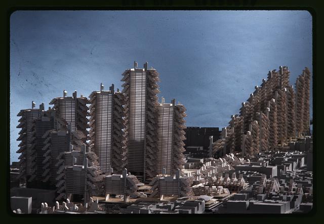
Featured image (at top): Lower Manhattan Expressway, New York City. Model, wide view, architect Paul Rudolph, between 1967 and 1972, Prints and Photographs Division, Library of Congress
 Robert K. Nelson is director of the Digital Scholarship Lab and affiliated faculty in the American Studies Program at the University of Richmond. He has authored, directed, or edited digital humanities projects such as American Panorama: An Atlas of United States History, “Mining the Dispatch,” and an enhanced edition of the Atlas of the Historical Geography of the United States. He teaches and writes on antislavery and slavery in the nineteenth-century United States.
 Brent Cebul is Assistant Professor of History at the University of Pennsylvania. His scholarship sits at the intersection of urban and political history with topical interests in federalism, inequality, and political and economic development. His first book is Illusions of Progress: Business, Poverty, and Development in the American Century (under contract with the University of Pennsylvania Press). It is a history of how and why 20th century liberals repeatedly convinced themselves that stimulating business growth might fight poverty. At Penn, Cebul is also a Mellon Research Fellow at the Price Lab for Digital Humanities.
