
Editor’s note: This is the seventh post in our theme for January 2022, Urban Environmentalism. Additional entries can be seen at the end of this article.
By Adrián Lerner
Great rivers can seem capricious. In the Amazon rainforest, home to the Earth’s most powerful riverine system, river shifts can radically transform vast expanses in a matter of minutes, either flooding spaces that had spent years away from water or isolating waterscapes from the streams that feed them.
At the same time, large waterways have been at the center of the modern history of the urbanization of Amazonia. The jungle’s most populated urban center outside of Brazil, and the third largest after Belém do Pará and Manaus, is Iquitos, Peru, which is located in a key navigable section of the Amazon. With the introduction of steam navigation to South America during the rubber boom of the second half of the nineteenth century, the extractive industry penetrated the continent from the Atlantic coast along the Amazon and its main tributaries.
The acquisitive exploration was possible because urban enclaves like Iquitos, a riverine port city in the Peruvian department of Loreto, played key commercial and logistical roles. Iquitos was also central for the geopolitical ambitions of a Peruvian state eager to expand its presence into the rainforest borderland through a stable settlement, and it represented a pinnacle for the civilizational impetus of the new regional elites, rubber-era nouveaux riches eager to impress.
Alongside the savage, genocidal violence that the rubber boom unleashed against the indigenous peoples of Amazonia, the process is to this day associated with the abrupt and luxurious urban modernization of those times: the newly paved streets and boulevards, lavish public buildings like governmental palaces and theaters, and innovative urban amenities such as tramways and public lighting.
Less fixed in the imagination about urban Amazonia is the fact that many of these urban features, and the public works associated with them, were related to the complicated relationships between cities and rivers. In places like Iquitos, the so-called Amazonian urban Belle Époque was a process of socio-environmental restructuring.
At the center of these endeavors were parallel efforts to tame the waterways that ruled the regional landscape and to deal with the new social inequalities that emerged with large-scale urbanization.
Iquitos was founded as a Jesuit missionary settlement in the lands of the Iquito indigenous nation during the 1750s, in the margin of a western arm of the Amazon River. The key topographic markers in the vicinity of Iquitos are the Amazonas, Nanay, and Itaya rivers. The Amazon alone altered its course at least five times between the mid-eighteenth and the late-twentieth centuries. First, in the 1750s, it absorbed the Itaya, until then a tributary of the Nanay, flooding large swaths of land. A description of that shift reveals the Amazon’s power and scale; as one settler observed: “it swallowed many leagues of high mounts, with an infinity of thick trees, and created a terrible gulf with its swirl…such a monster is this king of all rivers.”[1] The change formed an “island” between two arms of the Amazon: the main body, and a smaller, Western reach, to the left of which, along a long esplanade over a cliff, rose Iquitos, then called San Pablo.
The Amazon drastically altered its course at least five times between the mid-eighteenth and the late-twentieth centuries. For decades, the city languished, as the Amazon receded, isolating the town soon after its establishment. Crucially, by 1840, the river broke again to run directly in front of Iquitos once more. As a consequence, the epochal transformations unleashed by the steamship had Iquitos as their Peruvian heart, which would not have been possible without its selection as a naval station, based on its access to the Amazon.
By the late 1880s, however, just as navigation intensified with the rubber boom, the river recoiled again. During the low water season navigation became dangerous and expensive. In 1887 local authorities considered building a canal to make the western arm navigable all year. However, even an enthusiastic supporter of the project worried that “if released to this stream, the Amazon might bury the city into its abyss.”[2] No canal was needed, and the western arm soon returned to Iquitos, just in time for the height of the rubber era. In 1905, after many years of negotiations, Liverpool’s Booth Steamship Company, a leading player in the rubber economy, inaugurated a pier in downtown Iquitos. Including a state of the art floating dock, the pier fostered the dynamism of Iquitos and its image as a “modern city.”
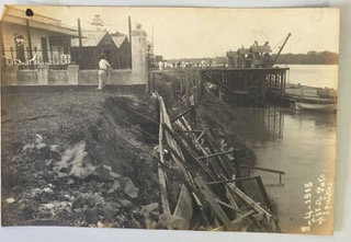
Unfortunately, it was a flawed endeavor, marred by a major ecological setback that could have been detected as early as 1899, when parts of the cliff downtown, right in front of the highest governmental office in Loreto, fell to the river. By then, the western arm had become the Amazon’s main course, hitting the bank with increased volume and power. In 1910, just as rubber prices peaked, strong rains and the swollen river threatened to erode other sections of Iquitos’s waterfront. The pier risked being detached, with potentially calamitous economic consequences, and it underwent major repairs.
The indigenous port and hamlet of Belén, adjacent to Iquitos’s downtown, at the time on course to becoming part of the city, suffered the worst effects.
Since then, waterfront erosion became a scourge. Major collapses took place during every decade of the twentieth century, until the 1980s. In 1920 the pier had to be completely dismantled and reinstalled for the first time. During the following decades, heavy rains often caused new, damaging landslides. Finally, in 1944 the structures from which the floating deck hung broke down after a collision with a raft, and the deck floated its way to the Atlantic Ocean.
In parallel to waterfront erosion, since the rubber boom era authorities had appointed specialists to design projects for water provision, canalization, drainage, pavement, and sewage systems. The rubber bust, felt since 1911 and definitive by the end of the decade, greatly affected their implementation. Plans and reports requested by local and national authorities emphasized the need to canalize water and dispose of it in the river, discussed in detail the relation of these issues to the stability of the built environment in the city center riverfront, and emphasized that the compatibility between the chemical composition of underground wastewaters and that of the soil could be important for the steadiness of the riverine sections.
For example, in 1918 when parts of the waterfront street were paved, engineers worried about erosion and argued that poor riverine neighborhoods like Belén, right next to the city center, could cause a disaster. They lacked water utilities. Water circulated, both in plain view and underground, polluted and uncontrolled, causing sanitary problems but also structural damage. And still, for decades, these experiences were not taken into account when dealing with the protection of the waterfront. Authorities associated erosion only with the Amazon River.
In the face of the continuing deterioration of the waterfront, the government contracted a study based on aerial photography in 1948. It confirmed previous diagnoses: the Amazon’s current struck the bank particularly hard between Belén and the city center.
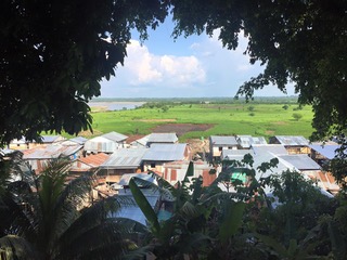
The report also documented the sudden formation of a massive, periodically flooded, swampy beach below and in front of Belén. By 1940 Belén, a large neighborhood, grew aggressively into the new space. Its inhabitants adapted to the environment, and built stilted and floating homes and businesses. These were traditional all over Amazonia, but such a concentration had not been seen in a Peruvian city. Belén was the most recognizable poor neighborhood in the city, suffering from poor sanitation, erosion, lack of running water, unsafe and flammable materials, and—as a consequence—frequent destructive fires. The growth of the lower section, called Lower Belén, made these issues more pressing, as shown by a series of devastating fires and by the recurrence of diseases influenced by environmental conditions. It was the most visible space of precarious urbanization in the Peruvian Amazon.
Only a few hundred meters downstream, riverbank collapses reached a critical point in the 1960s. Authorities ordered the evacuation of entire blocks along the Amazon. Collapses, once believed to be limited to Belén and contiguous neighborhoods, were seemingly moving downriver. The threat included valuable and symbolically charged places and strategic infrastructure.
Governmental agencies commissioned a number of new studies seeking solutions. They received geomorphological, limnological, and socioeconomic analyses; bathymetric charts; and cadastral maps. Reports invariably emphasized the urgency of the problem and proposed extraordinarily expensive solutions. One 1962 report claimed that “the safety of the city is seriously compromised, to the point that there has been talk of moving the city to a neighboring, more appropriate area.” Another study reported that “the lack of safety caused permanent anxiety among the local population.” An emergency committee for riverbank protection was created in 1963, and throughout the 1960s it consumed a large part of the city’s resources.
Only then did some experts begin to suggest that the crisis in the cliffs was directly related to the city’s groundwater table, which interacted with the river, rain, and wastewaters. In Belén along the river, septic tanks and pipes, where they existed, were overflowing. Their waters constituted a “sewage table” with a chemical composition that corroded the city’s waterfront. The river accelerated the process, but the collapses were largely anthropogenic, caused by the city’s historical interaction with the river. Rather than the ideal modern artifact discrete from “nature,” Iquitos was part of a complex ecosystem that included the human and the non-human.
This interpretation was accepted in most technical reports, but it did not gain policy traction. Proposed solutions included plans as radical as the diversion of the whole western arm of the Amazon from its bed. When the Peruvian government finally announced in 1995 that works to definitely end the landslides were beginning, they included the construction of massive concrete gravity retaining walls along two kilometers of Iquitos’s riverbank. National newspaper headlines read: “Defense Works Will End Half a Century of Landslides.”
The heterogeneous research corpus produced during those years reflected the impossibility of separating Iquitos as an ecosystem from Iquitos as a social formation, painting a broad, long-term image of the complex interactions between built environments and their ecological medium. Several studies acknowledged that the issue was defined by the interplays between the force of the Amazon River, the phreatic zone and water table, precipitation regimes, and the city’s drainage systems and wastewater management infrastructure. In terms of policy, however, responses perpetuated the tradition of treating erosion and sanitation policies as discrete problems.
The city was still conceptualized as an artifact distinct from, even opposed to, Amazonian nature, which it had to overcome, and from which it needed protection. In the process, they spent fortunes while leaving Iquitos’s most vulnerable peoples to their own devices.
Urban Environmentalism (January 2022)
- Driving into Environmental Law: Thurgood Marshall, Highway Construction, and the Overton Park Case (includes bibliography/reading list)
- Opposing Urban Energy Landscapes: Petitions and Letters against Coal Yards, Wood Yards, and Gas Stations in Montréal (1940s-1960s)
- Writing from Away: An Environmental Historian’s Dilemma
- The Racialized History of Philadelphia’s Toxic Schools
- Choosing Perpetual Management: Urban Runoff and the Origins of Its Mitigation
- The Greening of Detroit History
- Recreation and Reclamation of the “Richest Hill on Earth”

Adrián Lerner is a lecturer and postdoctoral research associate at the Free University of Berlin. A native of Lima, Perú, before moving to Berlin he completed his PhD in History at Yale University and was the Princeton Mellon Fellow in Urbanism and the Environment at Princeton University. He is currently working on his manuscript, based on his doctoral research, titled Jungle Cities: The Urbanization of Amazonia, a comparative social, political, and environmental history of urban growth in the rainforest in Brazil and Peru.
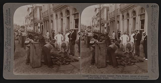
Featured image (at top): “Packing Crude Rubber, Para, Brazil, Center of Amazon River-System Trade” (ca. 1913), Underwood and Underwood, Prints and Photographs Division, Library of Congress.
[1] Manuel J. Uriarte, Diario de un misionero de Mainas. Transcripción, introducción y notas de Constantino Bayle (Madrid: Consejo Superior de Investigaciones Científicas / Instituto Santo Toribio de Mogrovejo, 1952 [1750-1767]), vol. 1, 155.
[2] Carlos Fry, “Diario de los viajes i exploraciones de los ríos Urubamba Ucayali, Amazonas, Pachitea i Palcazu[1886-1888]” in Carlos Larrabure i Correa, ed., Colección de leyes, decretos, resoluciones i otros documentos oficiales referentes al departamento de Loreto, Tomo XI (Lima: Imprenta de la Opinión Nacional, 1907), 486-487.
