
Editor’s note: This is the seventh in a series of articles during April that examine the construction of the Interstate Highway System over the past seven decades. The series, titled Justice and the Interstates, opens up new areas for historical inquiry, while also calling on policy makers and the transportation and urban planning professions to hold themselves accountable for its legacies. Additional entries in the series can be found at the bottom of the page.
By Amanda Phillips de Lucas
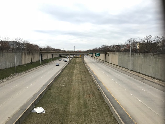
US 40, a 1.32 mile, six-lane freeway, cleaves west Baltimore in two. The sunken cavern of cracking asphalt stands as a testament—a monument of sorts—to the awesome human destruction wrought by the interstate project. As the alternative name of the road suggests, the “highway to nowhere” is a highway in form only. Local roads bookend the sunken cavern, doubling the injustice of its construction. Black neighborhoods of decades past mattered little to the engineers and public works officials determined to segregate through freeway modernism. These same officials began construction on the US 40 segment before the approval of the whole route—ultimately resulting in a fragmented road network surrounding Baltimore’s core.
The incomplete highway confirms what west Baltimore freeway activists from Relocation Action Movement (RAM) knew prior to the condemnations, to the displacement, and the wrecking ball: “We have been asked to make sacrifice after sacrifice in the name of progress, and when that progress has been achieved we find it marked ‘White Only.’”[1]
The steps leading to the “highway to nowhere” carry forward lessons on the promises and perils of community participation and engagement in road projects. In the contemporary moment, civic participation in the planning process is suggested to advance more equitable infrastructure projects.[2] But framing participation as a solution neglects the broader history of these practices.
In the late 1960s Baltimore was the home to an innovative partnership called the Urban Design Concept Team (UCDT). This team of designers, sociologists, architects, and planners worked with communities to provide a venue for citizen participation in highway planning. Yet, UCDT’s adoption and use of technical terminology ultimately alienated some residents. As west Baltimore activists experienced, participation often emerged as a way to silence viewpoints and devalue Black and poor neighborhoods. Given the growing support for removing racist highways, these early instances of participatory methods deserve a new eye as policymakers and planners consider best practices for restoring and repairing neighborhoods harmed by interstates.[3]
Baltimore’s highway planning began in earnest in the 1940s. Conflict over route selection arose almost immediately. Planners and engineers debated an arterial route through west Baltimore or a bridge that would bypass the city through the Harbor. To determine the placement of the route, Mayor Theodore McKeldin assembled the Harbor Crossing – Freeway Committee. This committee commissioned Robert Moses and engineer W. Earl Andrews to determine an “impartial and authoritative” route.[4] Moses and his team released the Baltimore Arterial Report which advised placing a highway through the Franklin-Mulberry corridor.[5] The report also called for the displacement of 19,000 residents. The sheer human toll of this proposed route led one committee member to remark that the plan “poses a mountain of human misery.”[6]
Despite these early planning efforts, the beginning of World War II shifted resources away from freeway investments.[7] Yet, this early debate made a lasting impact. From that point forward, the Franklin-Mulberry corridor, in the eyes of city officials, became the desired location for an arterial route into the urban core.[8] The residents and businesses that faced displacement under these plans were often poor and working-class Black families.[9]
With the passage of the Federal-Aid Highway Act and the resulting rush to get projects in the ground, the corridor gained renewed interest for the debut segment of an interstate system. By the 1960s, over two decades after the original route proposals, the affected neighborhoods suffered dual injustices. The initial proposals amounted to a self-fulfilling prophecy. The highway plans and looming condemnations limited the investments made within the neighborhoods, making the area even more desirable for highway placement. The 10-D plan, released in 1961, confirmed this trend by routing the western alignment through the corridor.[10] Ultimately, the eventual condemnations of homes in the Harlem Park, Franklin Square, and Rosemont neighborhoods led to the formation of RAM in 1967.
The rising dissatisfaction amongst residents, coupled with a few well-attended and reported public hearings, led to the creation of the UCDT.[11] Formed in 1967 through a joint venture between the State Roads Commission and four independent contracting, engineering, and architecture firms, UDCT brought together interdisciplinary practitioners to perform “comprehensive highway planning.”[12] As the contract for this venture stated, “the Interstate System in Baltimore must function as an efficient transportation facility, as well as meet the social, economic and aesthetic needs of the City’s environment.”[13]
Despite this lofty mission, the UCDT, specifically the principal architecture firm involved in the project, Skidmore, Owings, and Merrill (SOM), was contractually forbidden from altering the proposed highway plans. SOM could only improve upon the design elements along the route. This limitation veered towards coercion as the other principal on the project, the engineering firm J.E. Greiner Company, created (and stood to profit from) the contested 10-D plan. Eventually, an amended contract allowed the SOM design team to propose new routes in 1969.[14]
As SOM began their contracted design work, the sociologists, architects, and planners who made up their team established an office in the heart of the Franklin-Mulberry corridor. The office developed and utilized a “structure for citizen participation”[15] that emphasized outreach and engagement with “communities most directly involved in the highway program.”[16] Residents were encouraged to visit the offices, examine highway, joint-development, and interim use plans, and specifically “review what others have done and add to the ideas.”[17]
The offices also became a place for residents to immerse themselves in and learn from the language of highway planners and engineers. Soon, highway activists began using this newly acquired knowledge in public hearings to refute the technical merits and justifications of the highway.[18] The emergence of such tactics amongst Baltimore’s many highway activist groups led Joseph Axelrod, chief of the Interstate Division of Maryland, to accuse the design team of using their position to “support the enemy.”[19]

The use of engineering terminology by highway activists marks a major discursive shift. Activists armed with data and traffic projections challenged the veracity of the highway itself. These tactics are a stark contrast to the language, most often used by RAM and west Baltimore activists, who sought to establish the value of their neighborhoods, their communities, and their homes. Indeed, testimony from RAM members at public hearings often stressed the need for increased compensation for displaced residents, awarding construction contracts to Black business owners, and considering the public transit needs of local communities.[20]
Ultimately, SOM’s participatory practices resulted in activists prepared to challenge the technical merits of the highway but allowed little room for the more nuanced refutations grounded in social and spatial experiences. Yet, within these local understandings were powerful assertions of not only what the road would take away, but visions of how a highway and neighborhood could coexist. Resurfacing these demands and dreams must be at the forefront as we consider a future beyond interstates.
Developing lay expertise is an often-cited tactic of activists seeking to alter scientific or technological structures.[21] While this tactic proved effective at garnering the attention of the press, a series of lawsuits proved most effective at halting Baltimore City’s dreams of an urban interstate.[22] In the case of Baltimore, embracing this approach reified highway plans and pivoted attention to questions of technical legitimacy. Framed differently, activists contested the tools within the engineers and planners lexicon without questioning why these tools were used to displace and dispossess.
With the injustices of the interstate project clear, planners and policymakers should also question the goals and methods utilized in their contemporary participatory practices. Participation often requires acquainting residents with technical terms, regulations, and rules that dictate the scope and shape of projects. It is time to consider how these framings may curtail the ideas that emerge from the experience of living with and amongst the material harms of the interstate.
The utilization of participatory practices plays off of a desired, but often unfilled, promise of democratic self-governance. Participation in public projects signals the recognition of community voices and perspectives in the creation of our shared material environment. Given this potential, it is no surprise that planners and policymakers turn toward civic input to shape the future of infrastructures. Yet, if we desire to build structures that repair and restore, it is time to frame these approaches through the words, experiences, and desires of the people living amongst the shadowy caverns of our interstates.
- Sarah J. Peterson, “The Myth and the Truth about the Interstate.”
- Rebecca Retzlaff and Jocelyn Zanzot, “The Interstates Planned Violence and the Need for Truth and Reconciliation.”
- Ruben L. Anthony Jr. and Joseph Rodriguez, “Harnessing the Memory of Freeway Displacement in the Cream City.”
- Danielle Wiggins, “Remembering Sweet Auburn before Expressway: What Nostalgia Reveals about the Limits of Postwar Liberalism.”
- Kyle Shelton, “Right In The Way: Generations Of Highway Impacts In Houston.”
- Tierra Bills, “A Contemporary Path to Transportation Justice”.

Amanda K. Phillips de Lucas is a Postdoctoral Research Associate at the Cary Institute of Ecosystem Studies. She received her PhD in Science and Technology Studies from Virginia Tech in 2018. She is interested in how social understandings of space shape the production of infrastructure systems. Her research interests include the history of technology, infrastructure studies, and urban environmental history.
Featured image (at top): View West from Calhoun Street Bridge, U.S. Route 40, Baltimore, Eli Pousson, 2018, Flickr.com.
[1] “Relocation Action Movement.” 1968. Movement Against Destruction Records; Series 7, Box 7, Folder 105. University of Baltimore Special Collections and Archives. 6.
[2] Allen, Barbara L. 2018. “Strongly Participatory Science and Knowledge Justice in an Environmentally Contested Region.” Science Technology and Human Values, 1–25. https://doi.org/10.1177/0162243918758380.
[3] McLeod, Ethan. “With support in Washington, leaders say ‘this is the moment’ to plan removal of Baltimore’s Highway to Nowhere.” Baltimore Business Journal. March 2020. https://www.bizjournals.com/baltimore/news/2021/03/15/highway-to-nowhere-federal-momentum-tear-it-down.html?fbclid=IwAR0ddTsr7GXMkkWeuojknRjB2dyJWIjNA_oM4sWFrjR1DyzFfBvkgdxTfsU
[4] Brune, Herbert M. 1944. “Analysis of Freeway Proposal, 1944-10-11”. Movement Against Destruction Records; Series VII, Box 7A, Folder 1; University of Baltimore Special Collections and Archives. 1.
[5] Moses, Robert M. 1944. “Baltimore Arterial Report,” SASB M2 – Milstein Division – Room 121 – New York Public Library.
[6] Brune, 10.
[7] Mohl, Raymond A. 2004. “Stop the Road: Freeway Revolts in American Cities.” Journal of Urban History 30 (5): 674–706. https://doi.org/10.1177/0096144204265180. 689-690.
[8] Phillips de Lucas, Amanda. 2020. “Producing the “Highway to Nowhere”: Social Understandings of Space in Baltimore, 1944-1974. Engaging Science, Technology, and Society. (6).360. https://doi.org/10.17351/ests2020.327.
[9] Lieb, Emily. 2010. “Row House City: Unbuilding Residential Baltimore, 1940–1980.” Dissertation: Columbia University. 138. and Pietila, Antero. 2010. Not in My Neighborhood: How Bigotry Shaped a Great American City. Chicago, IL: Ivan R. Dee. 219.
[10] Giguere, Andrew M. 2009. “‘…and Never the Twain Shall Meet’: Baltimore’s East-West Expressway and the Construction of the ‘Highway to Nowhere.’” Dissertation: Ohio University. 100-112.
[11] “Rosemont Public Hearings – Rescind Condemnation Ordinance, 1973-06-21” 21 June 1973; Movement Against Destruction Records; Series 6: Box 6. Folder 56. University of Baltimore Special Collections and Archives, 2.
[12] Wong, Sidney. 2013. “Architects and Planners in the Middle of a Road War: The Urban Design Concept Team in Baltimore, 1966–71.” Journal of Planning History 12 (2): 179–202. https://doi.org/10.1177/1538513212471167.
[13] “Urban Design Concept Team – Part 1: 1967-09-09-,” 1967; Movement Against Destruction Records; Series 7, Box 8. Folder 1. University of Baltimore Special Collections and Archives, 5.
[14] Urban Design Concept Associates- Franklin/Mulberry Corridor,” 1969; Movement Against Destruction Records; Series 2, Box 7, Folder 125. University of Baltimore Special Collections and Archives, 4.
[15] Wong, 199.
[16] “Relocation Action Movement,” 26.
[17] “Urban Design Concept Associates- Franklin/Mulberry Corridor,” 2.
[18] “Rosemont Public Hearings – Rescind Condemnation Ordinance, 1973-06-21” 6.
[19] Keidel, Janelee. 26 August 1969 “Ulterior Designs Hinted in Urban Design Offices.” The Sun (1837-1989). Section C. 6.
[20] Phillips de Lucas, 364.
[21] Epstein, Steven. 1995. “The Construction of Lay Expertise: AIDS Activism and the Forging of Credibility in the Reform of Clinical Trials.” Science, Technology & Human Values 20 (4). 408–37. https://doi.org/10.1177/016224399502000402. and Wynne, Brian. 1992. “Misunderstood Misunderstanding: Social Identities and Public Uptake of Science.” Public Understanding of Science 1. 281–304. https://doi.org/10.1088/0963-6625/1/3/004.
[22] Mohl, 697.

Well-thought and interesting take—I’d never considered the discursive framework of these projects at all, or the way they may have limited choices on all sides. I’d add what I think are two important considerations you’ve probably discussed elsewhere in the series. One, the limited amount of housing available to Blacks in Baltimore (the city having been one of the earliest to pass housing segregation laws), which magnified the loss of even substance housing for a population already terribly squeezed physically and financially. Two, the fact that the Highway to Nowhere plan, when it did get stopped, got stopped by WHITE activist groups, who presumably had more voice and more influence and pull. Baltimore’s housing history is a disgrace, and it’s even more disgraceful how few of its white residents really understand it.
LikeLike
I meant “substandard “ housing, darn autocorrect
LikeLike