

Toronto’s suburbs have always been precisely the same as those of every other North American city: they have never conformed to stereotype. Now the stereotype – but do I really need to say this? – says that suburbs are low-density, white, middle-class residential environments. In varying combinations, however, Toronto’s suburbs have always included industry and commerce, along with residential areas of mixed densities occupied by workers and immigrants of diverse cultural backgrounds. I suppose much the same could be said of the suburbs of many American cities, although Toronto’s do have a uniquely Canadian twist.[1]

To be sure, the historical combinations have always included some suburbs that fit the cliché. In the 1880s, an upper-middle class area of single-family homes grew up northwest of downtown which, when annexed, became know as – wait for it – the Annex. In time, Jane Jacobs – yes, that JJ – became its most famous resident.[2] By then, it was a gracious city neighborhood. In the 1920s, other middle-class suburbs sprang upSoon after, an upmarket version was created in Kingsway Park.[3] Life in that sort of suburb was later described by Phyllis Young in The Torontonians, which was highly praised at the time – the New York Times called it “wise and witty” – but which has been neglected since. Anticipating later feminist critiques, Young portrays the setting as a “gilt-edged suburban labyrinth” for her female protagonists.[4]

Then, not surprisingly, the early postwar years saw plenty of auto-oriented tracts, with their characteristic loops and lollipops, together with busy arterials to keep them alive. This was a period of great changes in land development and finance. Until the early 1950s, the majority of residential mortgages were held by individuals. But, encouraged and guided by the federal government through the Canada (now Central) Mortgage and Housing Corporation (est. 1946), institutional lenders became much more involved. As municipalities began to download the responsibility for installing basic infrastructure, large developers became the norm. The model for many was Don Mills, which has been described (inaccurately) as Toronto’s first planned suburb.[5] And today, if you are prepared to drive an hour (or two, during rush hour) until you qualify, you will find something similar in far-flung places such as Aurora.

But such places have never been ubiquitous, nor even the norm. While the Annex was a-borning, West Toronto Junction was becoming home to industry. A rail hub, it incorporated as a Town in 1889 before being annexed in 1909. In the early decades of the twentieth century, while Toronto boomed as a diversified manufacturing, wholesaling and financial centre, all around the city owner-builders made shacktowns into modest owner-built suburbs such as Earlscourt.[6] During the next boom, after 1945, owner-builders went to work again. They were assisted by lumber dealers who sold house plans, while offering extended credit as well as evening classes in the rudiments of construction. The credit was crucial because institutional mortgage lenders effectively ‘black-balled’ the areas of owner-building as being too risky.[7] These amateur builders included the parents of Canadian writer Antanas Sileika, who describes the processes of building and living in such a place in his memoir, Buying on Time. The neighbors, mostly working or lower-middle class, eventually made the modest sorts of two- and three-bedroom bungalows that commercial builders were erecting at the same time.[8]
![A street in Earlscourt. - [ca. 1910]](https://themetropole.blog/wp-content/uploads/2019/09/harris-figure-4.jpg?w=750)
The inhabitants of these various suburban dwellings could be described as white and middle class on only the most elastic of definitions. Earlscourt was built by the sweat equity of penniless British immigrants. Sileika was the son of ‘displaced persons’ from Lithuania (which, incidentally, has just awarded him a prize for Lithuanian book of the year). High-rise apartments housed young singles and couples with high hopes but modest incomes, while of course public housing is designed to house be poor. Poverty has been disproportionately concentrated among immigrants, including those that Canadians call ‘visible minorities’, basically anyone who perceives themselves to be nonwhite. As a result, suburbs like East York, now part of the inner-ring, are very far indeed from the stereotype, as David Chariandy has described in Brother. Outsiders often stereotype such places as dysfunctional, but local journalist Doug Saunders has argued that places such as Thorncliffe Park in East York function very effectively as Arrival Cities for immigrants. As enclaves, they provide social, commercial, and immigration services to people who are struggling to learn English and to negotiate unfamiliar urban terrain in a strange country.[10]
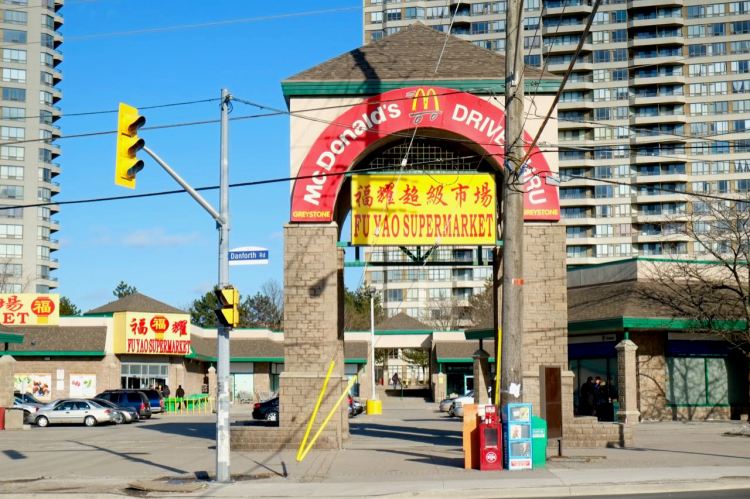
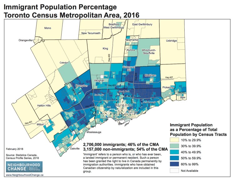
In some ways, the outer ring is the same. To be sure, it is mostly middle class. But more than half of the outer suburbs – amounting to half of the population of the metro area – are first generation immigrants. Given their sheer numbers, this has been inevitable: most could not be accommodated by the inner suburbs, still less the inner city which, since 1970s, has been gentrifying and becoming increasingly unaffordable. These new immigrants are indeed visible. Markham is the home of Chinese-Canadians and Brampton of Indo-Canadians. In recent years, people have begun to talk about ethnoburbs, outer enclaves of recent arrivals. But around Toronto, ethnoburb almost defines an entire Burgessian ring. It is only when you get to exurban territory that Canada’s Anglo heritage reasserts itself.[11]
No metro area’s suburbs have conformed perfectly to any stereotype and Toronto’s have failed to conform in their own peculiar ways. A century ago, even in Canada, hardly any cities received quite so many working-class British immigrants who fancied themselves as handymen; in the early postwar years, at a time when institutional finance was only just beginning to dominate, suburbs of amateurs were effectively red-lined; in the 1960s there were surely no American suburbs that saw so many high-rises; today, is there any metro’s outer suburbs that contain such a high proportion of immigrants? Contrary to another stereotype, very little of this was planned. Largely by chance, notably as a result of transnational migrations, Toronto has gone its own way.
Past president of the UHA (2017-18), Richard Harris teaches urban geography at McMaster University, Hamilton, Ontario. He has written several accounts of Toronto’s suburban development, notably Unplanned Suburbs. Toronto’s American Tragedy, 1900-1950. (Baltimore, 1996).
Featured image (at top): Toronto, photograph by Stephanie Swift, September 6, 2019, courtesy of flickr.com
[1] For an historical overview of Toronto’s suburbs see Richard Harris, “Using Toronto to explore three suburban stereotypes,” Environment and Planning A 47,1 (2015): 30-49. On Toronto’s modern evolution see Edward Relph, Toronto. Transformations in a City and Its Region (Philadelphia: University of Pennsylvania Press, 2014).
[2] For an account of the twentieth-century evolution of the Annex see Peter W. Moore, Zoning and neighbourhood change. The Annex in Toronto, 1900-1970.” The Canadian geographer 26,1 (1982): 21-36.
[3] Ross Paterson, The development of an interwar suburb. Kingsway Park, Etobicoke. Urban History Review 13: 225-235.
[4] Phyllis Young, The Torontonians; a Novel (Toronto: Longmans, Green, 1960). This quotation is discussed in Amy L. Harris’s very useful Imagining Toronto (Toronto: Mansfield Press, 2010), a fine survey of Toronto in fiction. (That’s an objective judgement: she’s no relation!)
[5] For discussion of Don Mills which puts it in context see Richard White, Planning Toronto. The Planners, the Plans, their Legacies, 1940 to 1980. (Vancouver: UBC Press, 2015), 103-113.
[6] On the Junction, Earlscourt, and Toronto’s suburban development in the early twentieth century see Richard Harris, Unplanned Suburbs. Toronto’s American Tragedy, 1900-1950. (Baltimore: Johns Hopkins University Press, 1996).
[7] Richard Harris, From ‘black-balling to ‘marking’: the suburban origins of redlining in Canada, 1930s-1950s. The Canadian Geographer 47 (2003): 338-350.
[8] Antanas Sileika, Buying on Time (Erin, Ont.: Porcupine’s Quill, 1997).
[9] On Markham’s New Urbanism see David Gordon and Shayne Vipond, Gross density and New Urbanism. Comparing conventional and New Urbanist suburbs in Markham, Ontario. Journal of the American Planning Association 71 (2005): 41-54. For mapping of present-day suburbs see the Atlas of Suburbanisms, School of Planning, University of Waterloo. https://uwaterloo.ca/atlas-of-suburbanisms/maps-and-data/mapping-dimensions-suburbanism. For an interpretation of Toronto’s changing social geography since 1970 make a note of Alan Walks, Inequality and neighbourhood change in the Greater Toronto region, in Jill Grant, Howard Ramos and Alan Walks, eds., Changing Neighbourhoods. Social and Spatial Polarization in Canadian Cities (Vancouver: UBC Press, in press). This forthcoming book will contain comparable interpretations of most major Canadian cities, including Hamilton, Canada’s best-kept secret.
[10] David Chariandy, Brother (Toronto: McClelland and Stewart, 2017); Doug Saunders, Arrival City. The Final Migration and the Next World (Toronto: Knopf, 2010). What are referred to as Toronto’s inner-ring suburbs were amalgamated with the City of Toronto in 1998. Unlike American states, Canadian provinces have the power to do such things.
[11] For a concise discussion of the ethnic geography of metropolitan Toronto see Mohammed Qadeer, S.K. Angrawal and A. Lovell, Evolution of ethnic enclaves in the Toronto metropolitan area, 2001-2006. International Journal of Migration and Integration 11 (2010): 315-319. The NIMBY politics of the exurbs is on display in L. Anders Sandberg, Gerda R. Wekerle and Liette Gilbert, The Oak Ridges Moraine Battles. Development, Sprawl, and Nature Conservation in the Toronto Region (Toronto: University of Toronto Press, 2010).

Transportation politics is Toronto is exceedingly weird since it mostly consists of the old-money white population in the biege sections of the map crowing about how “diverse” their communities are and denouncing plans to improve transit in the blue sections as pandering to the desires of deplorable white racists.
I would never in a million years have imagined that projection of that magnitude was even humanly possible.
I can only conclude that intelligent life on other planets doesn’t exist given that it hasn’t wiped us out out of sheer self-preservation.
LikeLiked by 1 person
@MOMENT OF INERTIA
While you’re not wrong to point out the neoliberal dishonesty, in Toronto’s case the blue sections of the map tend to lack a dense, walkable and mixed enough environment to make building rapid transit in those areas feasible. They’re just much too auto-centric and the damage has already been done. It speaks to a larger issue that these are the places that “New Canadians” call home; neighbourhoods that lack the rich urban fabric that many “Old Canadians” in the same city enjoy.
LikeLike