

Though still undergoing construction, Bunker Hill Refrain, a digital humanities endeavor from the University of Southern California, provides a window into an innovative project that has at once taken shape but is also still taking full form. A synecdoche for the city’s larger history, “Bunker Hill is emblematic of the choices we made,” notes Meredith Drake Reitan, co-director of Bunker Hill Refrain. “It is key to understanding how we got the Los Angeles that we currently occupy.” While the project is closing in on the completion of a pilot section of the digital model, the next phase, which concerns the addition of neighborhood blocks and historic data, will likely take another year. Drake Reitan sat down (virtually) with The Metropole recently to discuss Bunker Hill Refrain and its relationship to Los Angeles’s history.
Considering how much Los Angeles has been redeveloped since 1945, what is it about Bunker Hill’s history that distinguishes it from that of other Angeleno communities that have undergone similar transformations?
I’m always surprised at the response I get when talking about Bunker Hill. The neighborhood looms large in the city’s collective imagination. Possibly because it has something for just about everyone: lost Victorian architecture, a beloved short funicular, urban planners run amok. For much of the early twentieth century, the hill served as a source of artistic and literary inspiration, which reinforced this imaginative hold. The neighborhood was a Hollywood noir backdrop, but also a place where painters, photographers and writers lived and worked.
Bunker Hill was among LA’s first and largest redevelopment sites. Its downtown location is immediately adjacent to city hall and the civic center. This kept the hill on the minds of LA’s political class, who had considered it a geographical impediment to development since as early as the 1920s.
There is also something about the clash of Bunker Hill with LA’s vision of itself as a city of the future. It works as a synecdoche, where one small neighborhood comes to represent the city’s larger history. Bunker Hill is emblematic of the choices we made. It is key to understanding how we got the Los Angeles that we currently occupy. In a city as large as LA, there are obviously other examples—Chavez Ravine, old Chinatown, and Venice come to mind. These neighborhoods serve a similar function, and I see Bunker Hill as part of a pantheon of places that continue to speak to Angelenos, even if they are gone.
Sometimes this could be described as nostalgia, but there’s also an unresolved anger. When I talk about the neighborhood with students in USC’s planning or heritage conservation program, they see an alluring vision of a Los Angeles that could have been. On the surface, Bunker Hill was a centrally located, walkable community that was well connected to public transit and included a mix of housing types for a diverse population. This is heady stuff for planners who grapple with the city today.
One of the more innovative aspects of Bunker Hill Refrain is its use of WPA Housing census cards to recreate Bunker Hill’s past. Can you describe these cards? How did you decide to use them to recreate the pre-redeveloped neighborhood?
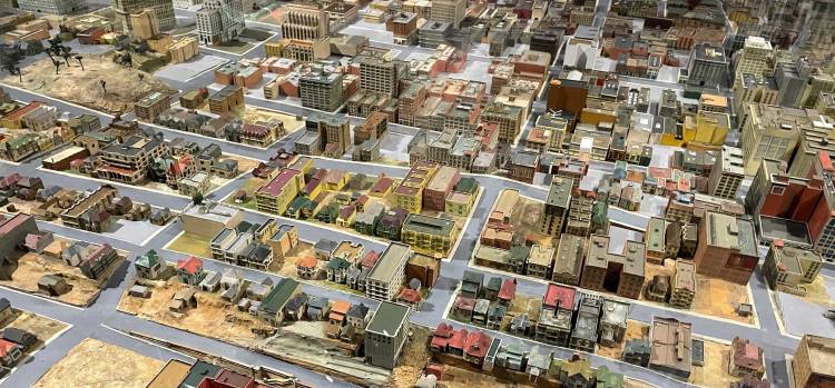
Bunker Hill Refrain relies on two WPA-funded efforts: a survey conducted in 1939 by the City of Los Angeles’s Housing Authority and an architectural model built around the same time by the Bureau of Engineering for the Planning Department.
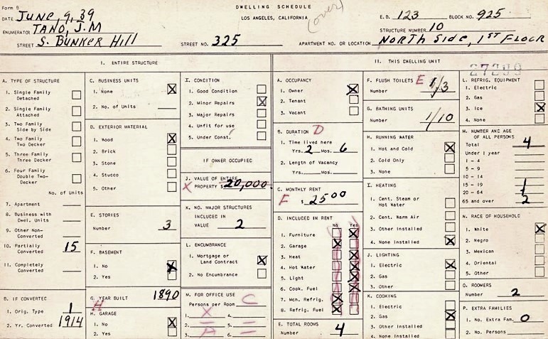
In order to qualify for funds to support public housing, the federal government required a detailed assessment of current conditions. Los Angeles was one of hundreds of cities that used a survey to make their case. As part of the process, WPA workers visited neighborhoods and interviewed residents across the city. They recorded their findings on more than half a million 5 x 7 cards. The cards contained information about individual buildings, including dates of construction and conversion, building materials, and amenities. The cards also provided a picture of the building’s inhabitants, including their ownership status, length of residence, rent, and their race or ethnicity. This combination of architectural and social data tied to specific addresses at a particular moment in time makes the cards incredibly valuable for scholars of Los Angeles.
The Housing Survey records were donated to the USC Library in the 1940s. Fifty years later, a selection of cards was digitized and made available as JPEG image files in the USC Digital Library. However, the cards are considered to be a hidden collection that exists in plain sight. There is currently no way to systematically retrieve and analyze the hand-written data from the cards.
A chance conversation with Special Collections Librarian Suzanne Noruschat got us thinking about ways to make the cards more accessible. Rather than try to tackle the whole collection, we decided to focus on a small sample. There are about 5,000 cards located within the boundaries of the 1958 Bunker Hill Urban Redevelopment area, and so this seemed like a reasonable place to start. Suzanne brought in Andrzej Rutkowski, also from the USC Libraries, who helped us think through the early phases.
We initially started out as a transcription project. More recently, through a collaboration with Curtis Fletcher, director of USC’s Ahmanson Lab, we have been able to link the data on the cards to a digital representation of Bunker Hill when it was surveyed. To create the digital representation, we relied on architectural drawings and a model of downtown Los Angeles created by the city’s Bureau of Engineers. With Sanborn maps serving as the base, we’ve used the WPA sources to recreate the houses on Bunker Hill as enumerators would have seen them.
We’re hoping that the transcribed survey cards and digital model, combined with info from the US Census and other primary sources, will provide a more nuanced understanding of everyday life on Bunker Hill in the 1930s. On the website, visitors will be able to “walk” down streets that do not exist anymore and get a sense of the neighborhood as a real place, rather than the myth that developed around it.
What aspect of building the project has been the most surprising? The most challenging?
I’ve loved discovering new things about a place that I thought I knew well. For one thing, Bunker Hill is a lot more colorful than I’d imagined. We used the colors on the WPA model to create a palate for the digital representation. I watch a lot of film noir and have always been interested in historic photographs, which are obviously mostly in black and white. I was surprised to realize the houses on the hill were painted bright sunshine yellow, or deep green and baby blue.
I’ve also really appreciated our ability to identify individual stories. Much of my previous work has been about planning as a profession, and while I’ve always been interested in planning’s relationship to communities, I don’t think I’d spent much time thinking about specific individuals. By putting names and life histories to the residents on the hill, the story of its demolition now seems less abstract to me.
The expansiveness of the digital possibilities has also been amazing. There’s a lot of “how about this?” or “what about that?” in our team meetings. This has been great fun. And yet, probably because there are so many different paths we could follow, it is sometimes hard to capture and guide this energy. I’d like to say that we’re systematically following an established research agenda, but the discovery and building process is more fluid than that. Also, like many large projects, we’re short on funding and dedicated time. This means that things get done in spurts of activity. We’ve been fortunate to receive support from a number of internal sources, but the next step is to get the project ready for bigger and more reliable funding.
Looking over the various team members from the co-directors down, you’ve clearly assembled a team grounded in an interdisciplinary approach. To what extent is an interdisciplinary approach just a given for digital humanities projects at this point, and how difficult have you found it to harmonize such efforts?
The project as it is currently conceived could not have been done without the larger team. Initially, we started with a fairly small idea about simply transcribing the WPA survey cards. New team members with different skills and interests widened our sense of what is possible. This is likely because we are in the relatively early stages of development where we can tinker and explore without significant risk. As the project grows and we move beyond the initial production phase, we will probably add new contributors that put their stamp on the project. We plan on making the project files available through an open-source platform, and it is our hope that other scholars will engage with the transcribed data to tell different stories in new ways.
Based on some of our email exchanges, Bunker Hill Refrain is being incorporated into class curriculum at USC in such a way that students will produce social histories of selected buildings in the community. While not exactly crowd sourcing, it is related to that approach and seems to be a growing trend in the digital humanities. How integral are these sorts of approaches to Bunker Hill Refrain and similar projects?
There is a practical aspect to the crowd-sourcing idea—the project is big enough that it can only be moved forward by a group. However, the approach is also foundational to our thinking. Using the Zooniverse platform, we initially asked volunteers and the public to assist in the process of getting information from the survey cards. We were able to transcribe about 700 cards this way. However, we found that getting usable data back out of Zooniverse was a little harder than we’d expected. We’re still working on sorting out those kinks and we’ll probably re-launch the Zooniverse program this fall. The crowd sourced effort is an important way to connect to a larger community and it re-enforces the public nature of the project.
I should also add that in terms of street level views and their incorporation into the interactive web version of the model (see here, here, and here for some examples), we are furiously adding info to the street views. In the very near future, viewers will be able to click on WPA survey info for each building.
We’re now two decades into the twenty-first century and over three decades since the publication of Mike Davis’s City of Quartz, which whether one agrees with its interpretation of Los Angeles history or not, most people acknowledge serves as a demarcation point that ushered in an increased interest in the city’s past—notably histories fixing a more critical eye on its history. As a historian of Los Angeles, what do you think of LA historiography in this moment, and where does Bunker Hill Refrain fit into it?
It certainly seems we have all agreed that LA has a history worth writing. I think we are also moving away from the image of the city as the great post-war, post-modern exception. For me, the most interesting LA historians are currently writing the city into national and global stories about racial violence, empire building, and settler colonialism. Also, and this probably isn’t unique to LA historiography, I have been reading a lot of work that uses small, fine-grained histories to tell larger narratives. I’ve found recent research focused on individual restaurants, business networks, neighborhoods, and even Zumba dance studios serve as good models for how to connect the local to larger forces.
In terms of where we fit in, I think the Bunker Hill Refrain project may tell us more about mid-twentieth-century migration to Los Angeles. By cross-referencing the WPA cards with the US Census, we’ve been able to identify individuals and families on the hill. Through a series of maps, we’ve been tracing where the residents of the hill came from. I’m also interested in re-framing the literature on redevelopment to think more about the displaced. For somewhere between 6,000 and 9,000 individuals, the story of Bunker Hill didn’t end when the buildings were torn down. I want to figure out where those people went and what effect that movement had on LA.
Mike Davis’s trope of LA as a place of both sunshine and noir was a useful device. It still holds true in a lot of respects, but I would like our work to go beyond that dichotomy. Boosters and bureaucrats shaped the neighborhood, but I hope our project provides a sense of the mundane and everyday life on the hill. The neighborhood was a community of individuals and families who deserve to be better known. We’re not there yet, but we’re working on it.

Dr. Meredith Drake Reitan is an Associate Dean in the Graduate School of the University of Southern California and an Adjunct Associate Professor in the Price School of Public Policy and School of Architecture where she teaches classes on urban design and heritage conservation. As a planning historian, her research offers an account of the culturally-situated rhetorical work deployed by planners and other professionals involved in shaping the urban landscape. She has written for academics and for the public, including articles in the Journal of the American Planning Association, the Journal of Planning History, the Journal of Urban Design and KCET’s Lost LA series, among others.
Featured image (at top): Photograph of the architectural model built by the City of Los Angeles Bureau of Engineers for the Planning Department. The model is currently on display at the Natural History Museum of Los Angeles County. The model, along with the sketches and renderings used to build it, were the source for Bunker Hill Refrain’s digital representation of the Bunker Hill neighborhood. Photograph by Meredith Drake Reitan.

Dr. Reitan….this is an amazing project. Please contact me. I’d love to talk to you. My name is Jeff Goertzen, art director for the Southern California News Group.
LikeLike