
By Jennifer Bonnell
Flying into Toronto, I am always struck by the density and reach of its urban tree canopy. In addition to the mature trees of its leafier, privileged neighborhoods, the city wraps itself around the forested, forking ravines of three major river valleys: from west to east, the Humber, Don, and Rouge River watersheds. A network of publicly-managed conservation areas within these watersheds, congregated mostly along the riparian corridors, form a well-used recreation corridor for cyclists and runners, birdwatchers and weekend picnickers (not to mention bats, raccoons, and coyotes).
But it wasn’t always so. Revitalizing the image and the experience of Toronto’s urban river valleys took time and effort—something Ontario’s current Conservative government has been quick to forget in its recent threats to cut funding from the conservation authorities that own and manage many of Toronto’s ravine lands, urging them to abandon public education and engagement initiatives to focus on their “core mandate” of conservation and flood protection.[1]

Forgotten in these cost-cutting measures, for example, are the efforts by the Task Force to Bring Back the Don, a citizen advisory committee formed in the late 1980s, to remove chain-link fences and construct pedestrian bridges to facilitate public access to the deindustrializing landscapes of the lower Don River Valley. Through wetland construction initiatives, river clean up days, and annual events like Paddle the Don, citizen groups and conservation authorities attracted volunteers and broader publics to come to know valley landscapes, and in doing so, to work for their protection.
Forgotten too are the efforts of an earlier generation of conservationists in forwarding a vision of urban river valleys like the Don as vital green “lungs” through which to restore harried urban minds and bodies. Chief among these was Charles Sauriol, a cottager in the Don Valley from the 1920s to 1960s and an ardent campaigner for the understanding and protection of valley green spaces.
When Sauriol founded the citizen-led Don Valley Conservation Association in 1949, he set out not only to protect valley lands from development, but also to overturn century-long associations of the Lower Don River and its branching ravines as dangerous, diseased landscapes to fear and avoid. These associations crystallized in Metropolitan Toronto Council Chair Frederick Gardiner’s description of the valley as little better than a “place to murder little boys” in debates over expressway development through the Valley in late 1950s.[2] But they had a long history.
In the early 1800s, the Lower Don River and the extensive Ashbridge’s Bay marsh at its mouth were widely understood as unhealthy places beset by miasmas (vapours arising from decaying organic matter that were thought to produce disease). Area resident John Bennett wrote to a colleague in 1801:
I am just recovering from a severe fit of fever and ague which confined me to bed for ten days past—no body can escape it who pretends to live here.… There is a marsh about [half] a mile from where I live from which a thick fog arises every morning – people attribute [the fever] in great measure to that and to the low and uncultivated state of the Country.[3]
The “ague” that Bennett suffered from was actually a strain of malaria—an almost inevitable, if rarely fatal, aspect of life in the developing city. At the time, however, the severe fever and shaking chills he suffered from were thought to result from inhaling the ‘bad air’ (hence mal/aria) of places like the Lower Don Valley.[4]
These perceptions of unhealthiness had significant implications for the city’s development. Founded in 1793 at the east end of Toronto harbor, not far from the mouth of the Don, the town of York (renamed Toronto in 1834) leaned westward by the 1830s, relocating its Parliament and other significant buildings away from the river valley to what were considered healthier and more fashionable quarters further west.
Eastern fortunes continued to fall, and by the 1860s the river valley had taken on a kind of “underworld” identity, providing refuge to gangsters and shelter for gambling, cock-fighting, and other illegal activities. Proximity to shipping and rail lines eventually led city politicians and industrialists to reimagine the Lower Don as an industrial hub, drawing upon Cleveland’s Cuyahoga River as a model for the straightening, canalization, and industrialization of the lower reaches of the river in the 1880s and ’90s. By the turn of the century, pollution from area industries, including slaughterhouses, soap factories, breweries, and oil refineries, further exacerbated the area’s unsavoury reputation.
And yet, alternative imaginings always existed for the Don. From the late-eighteenth-century illustrations of Elizabeth Simcoe, who built a modest summer home in the Don Valley with her husband, Lieutenant-Governor John Graves Simcoe, to the artists and naturalists who frequented the middle and upper reaches of the valley in the late nineteenth and early twentieth centuries, visions of the river valley as a place to value and protect have contended with the imaginings of industrialists and highway builders.
Sauriol picked up on this tradition in pressing for protections for valley lands in the mid-twentieth century. Together with fellow conservationists and naturalists of the Don Valley Conservation Association, he lamented the casual dumping of garbage along river banks and roadsides, and pressed for decorum in dissuading schoolchildren from picking wildflowers and harassing wildlife. Modest membership fees allowed him to produce a quarterly newsletter, The Cardinal, which educated readers about the wild residents of the valley and the conservation initiatives needed to protect them.

Ultimately, Sauriol’s efforts to see the valley recognized as a cherished urban place ran up against more powerful visions of the valley as a corridor for transportation and development. The construction of the Don Valley Parkway in the early 1960s radically transformed valley landscapes, laying a ribbon of pavement along the valley bottom and demolishing hills and other landforms. It also had deeply personal ramifications for Sauriol, resulting in the expropriation of his valley landholdings and the demolition of his beloved family cottage.

Sauriol persisted, relocating with his family to a second cottage property across the river, where he imagined running a conservation education center one day. Ironically, his plans would be upended by an organization that shared his views about the significance of the city’s river valleys, and the need for their protection. In 1968, the Metropolitan Toronto and Region Conservation Authority (MTRCA) expropriated his second cottage property as part of a broader floodplain acquisition strategy. Recognition of the value of the city’s river valleys as vital drainage corridors became especially pronounced in the aftermath of Hurricane Hazel, which ravaged southern Ontario in 1954. In the years that followed, the MTRCA had begun the process of acquiring and protecting floodplain lands in the valley bottoms. Sauriol—who sat on the MTRCA board—had become a victim of his own success.
Alienated by shifts to a more strident form of environmentalism in the 1960s and 70s, when groups like Pollution Probe held a funeral for the river and ran full page ads in Toronto newspapers compelling readers to act, Sauriol was gratified to see the lands surrounding his cottage opened to the public as a conservation area in 1989.
Over his long twentieth-century life (1904-1995), Sauriol contributed to a sea change in thinking about spaces like the Don River valley. His efforts to raise public awareness about the city’s green arteries received substantial aid from municipal authorities: the removal of five overburdened sewage plants in the 1950s and 60s, for example, and the creation of a network of city park spaces in the same period, did much to transform the experience of valley landscapes.
What conservationists like Sauriol, citizen groups, parks and conservation authorities have in common is an emphasis on public access and education as an avenue to protection. Their efforts, as Toronto urbanist Shawn Micallef noted in a recent article in the Toronto Star, have created a huge constituency of valley users.[5]
Invasive species, climate change, and short-sighted government administrations will continue to threaten Toronto’s beloved ravine systems.[6] And they will demand that this constituency, so deliberately created, take action to ensure their protection. Whether or not valley users will respond with the noise and urgency required will put to the test the beliefs of an earlier generation of conservationists that people will fight to defend the places they love.
 Jennifer Bonnell is an Associate Professor of History and Coordinator of the undergraduate Public History program at York University in Toronto. She is the author of Reclaiming the Don: An Environmental History of Toronto’s Don River Valley (University of Toronto Press, 2014) and the co-editor, with Marcel Fortin, of Historical GIS Research in Canada (University of Calgary Press, 2014). Her current book project explores the responses of nineteenth and early twentieth-century beekeepers to environmental change in the Great Lakes Region.
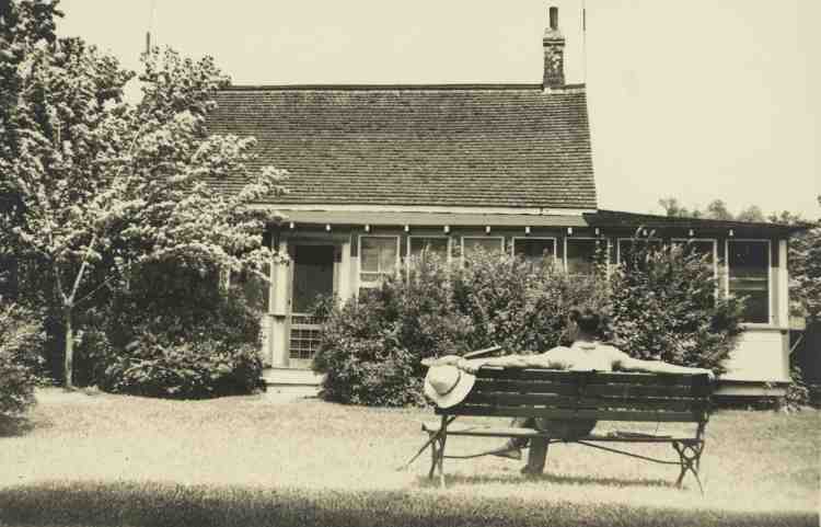
Featured image (at top): Charles Sauriol in front of the original cottage at the Forks of the Don, July 1935, City of Toronto Archives, Series 80, Photographs of the Don Valley, File 8.
[1] Robert Benzie and May Warren, “Ford Government Urges Winding Down of Conservation Programs to Conserve Cash,” The Toronto Star, 20 August 2019, https://www.thestar.com/politics/provincial/2019/08/20/ontario-government-urges-winding-down-of-conservation-programs-to-conserve-cash.html; While the creation of urban protected areas and the management of urban water has been a feature of all major Canadian cities in the postwar period, Toronto is unique in its early adoption of watershed-based management. The Ontario Conservation Authorities Act of 1946 enabled municipalities to partner in the creation of watershed-level conservation authorities. Of all the Canadian provinces, only Saskatchewan rivals Ontario for the age and longevity of its watershed conservation agencies (enabled by legislation in 1949); only in Ontario, furthermore, have these agencies had an urban as well as a rural focus since their origins in the 1940s. Manitoba modelled its conservation districts after the Ontario system in the 1970s. Other provinces have followed, adopting some form of watershed management, including basin-specific watershed boards, in urban and rural areas between the 1970s and the early 2000s.
[2] Michael Smith, “Love It or Hate It, Parkway’s 25 Years Old,” The Toronto Star, 13 August 1986.
[3] Edith G. Firth, The Town of York, 1793-1815: A Collection of Documents of Early Toronto (Toronto: Champlain Society, 1962), p.242.
[4] The strain of malaria prevalent in early nineteenth century southern Ontario was less deadly than its tropical cousins. As James L.A. Webb concludes, malaria lasted only a few generations in North America. The “principal and characteristic disease of the North American agricultural frontier,” malarial infections receded as crop cover stabilized disturbed, logged-over soils and habitat for mosquito-breeding shrunk (Humanity’s Burden: A Global History of Malaria (Cambridge and New York: Cambridge University Press, 2009), 5–6; 88–89).
[5] Shawn Micallef, “Conservation Authorities Make Ontario Liveable. We Need to Defend Them,” The Toronto Star, 30 August 2019, https://www.thestar.com/opinion/contributors/2019/08/30/conservation-authorities-make-ontario-livable-we-need-to-defend-them.html.
[6] The City of Toronto’s 2017 Toronto Ravine Strategy itemizes some of these threats to city ravine spaces and the protections needed to support their long-term resilience: https://www.toronto.ca/city-government/accountability-operations-customer-service/long-term-vision-plans-and-strategies/ravine-strategy/.

The mention of Charles Sauriol and his vision of the Don Valley as green “lungs” really stood out—especially how that idea was forged decades before the recent push for public access and restoration. Living in a city where ravines feel like hidden escapes, it’s sobering to think how easily that hard-won connection could be undone by political forgetfulness. Protecting those spaces means remembering the activists and volunteers who made them feel like ours in the first place.
LikeLike