
Editor’s note: Remember that SACRPH 2019, the organization’s 18th conference, is in Northern Virginia (NOVA or NoVa) this October/November from October 31 – November 3, the deadline for the CFP, which you can view here, is March 15. With this in mind, we begin our focus on NoVa as our Metro of the Month. Submit your panels everyone!
By Andrew Baker
Each weekday afternoon Northern Virginia commuters leave their offices in the District and drive across the Roosevelt Bridge, up interstate 66, and onto Harry Byrd Highway (state route 7) west through Tysons Corner and into Loudoun County. After the first few turns they pass their commute traveling along well-worn lines—experiencing the metropolitan region as a succession of images from a car window. Succession suggests series; series suggests transitions from one place to another. As they journey daily from the city the mind assumes gradation even as it experiences a succession of plot by plot land uses and zoning decisions. This experience quietly answers questions few articulate.
When do the suburbs begin?
When you see the first car dealership in Tysons Corner.
When does the countryside begin?
When you see the first open fields without for-sale signs mentioning “development potential.”
Where does rural America begin?
When you see the first gas station advertising “clean bathrooms.”
This commuters’ catechism mediates between the urban planner’s categories and the messy particulars of the built environment as drivers experience it. These daily journeys from the city press concentric circles of metropolitan development deep into the mind. As a native and later historian of Loudoun County, Virginia, the experience of driving west on route 7 has likewise formed my understanding of this particular metropolitan landscape—Western Loudoun County—in ways that are often difficult to articulate.
Western Loudoun, like the Catskills and the San Fernando Valley, is both a part of the metropolis and a frequently prescribed antidote to it. It is economically dependent on metropolitan dollars even as its partisans use those dollars to defend it from metropolitan encroachment. Western Loudoun is an example of that wonderfully flexible category—the metropolitan fringe. Such a label is more concession than explanation. It identifies but does not define.
The best way to make sense of Western Loudoun is to join the commuter in experiencing images of place. Here, then, I offer a series of historical glimpses of its twentieth-century history. Each seed grew into a part of the complex ecology of this metropolitan fringe region—Washington’s backyard.
What is Western Loudoun County?
An anti-urban, metropolitan region defined by health, horses, hamlets, and homesteads.
Snickersville
As a traveler drives west from Washington into Loudoun they leave the tidewater, move through the piedmont (literally “foot of the mountains”), and enter the Blue Ridge within a space of sixty miles. Here a sleepy village lined with stone walls lies down a hair-pin turn just off route 7, right before crossing the Appalachian Trail.
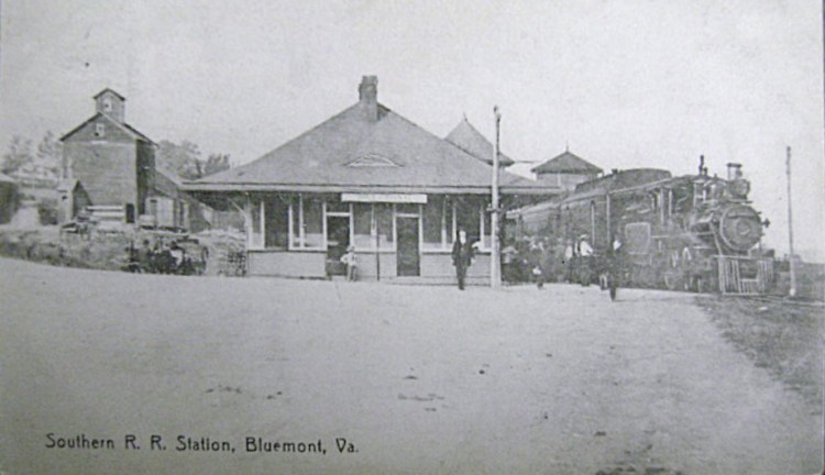
From the 1880s to the 1920s, summer trains brought Washingtonians out of the heat and humidity of the lower Potomac River into Western Loudoun’s Blue Ridge foothills. With the extension of the Washington and Ohio Railroad line (later the Washington and Old Dominion) to Round Hill in May 1875, the travel time from the city dropped to only two hours. Families rented summer homes or took out rooms in newly opened boarding houses while husbands commuted to the city for the week’s business. By the 1890s Western Loudoun hamlets enjoyed a thriving summer tourist trade.
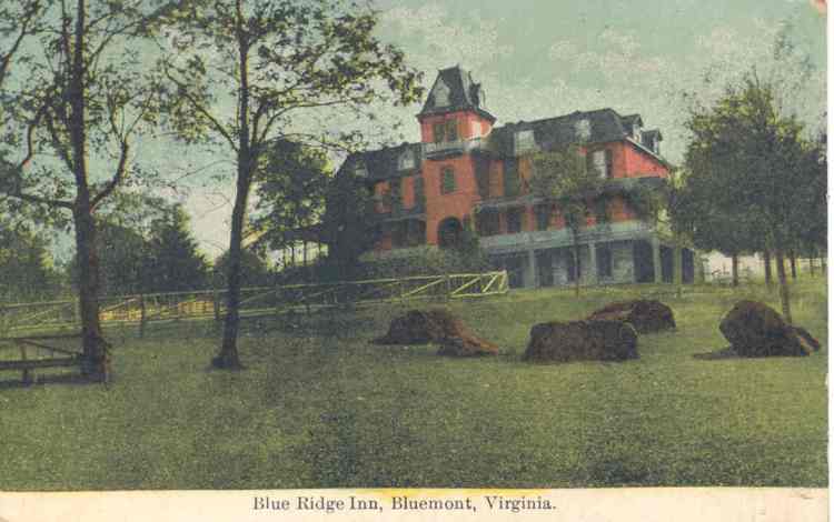
The unfortunately named village of Snickersville was the most popular of these summer retreats. Visitors came to ramble over the mountain ridges and gaze down at the Shenandoah Valley to the west and distant Washington to the east. The price of these beautiful vistas was a four-mile carriage ride up poorly maintained country roads that jostled and rattled guests before depositing them in the sleepy mountain town. Enough people made the trip to keep three small hotels in operation by 1885. It was Jules De Monet, a prominent chef from D.C., who put Snickersville on the map when he opened the Blue Ridge Inn in 1893. His new hotel added a level of sophistication the small resort town had lacked. Sophistication was good for business. In 1900, when the railroad extended the line to Snickersville, the company took the liberty of dumping its ill-fitting label for the more bankable Bluemont.
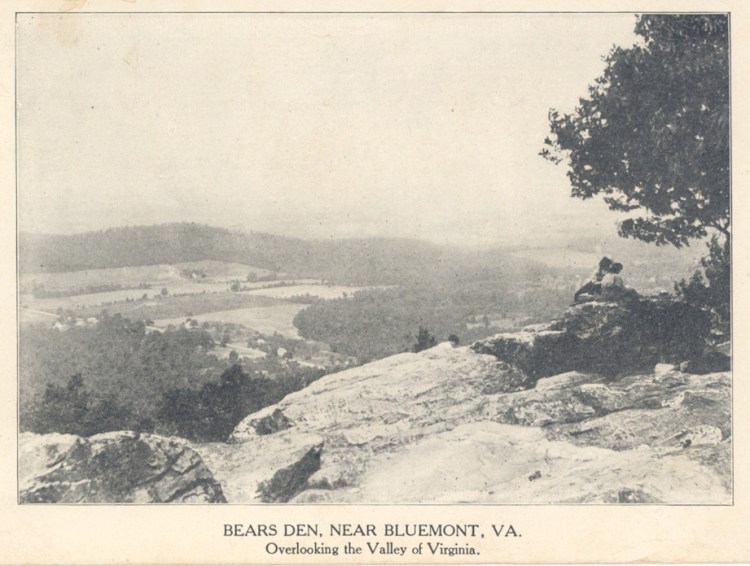
During the height of summer six trains pulled into this station from Washington and Alexandria each day with up to twelve coaches full of summer residents and tourists. Sunday trains brought up to thirty people for afternoon dinner. Here urban professionals sipped tea, played croquet, and socialized with other members of their class. The more daring dabbled in the “strenuous life,” hiking to Bear’s Den or hunting quail and turkeys in the surrounding woodlands. Some vacationers purchased land and had private mountain cottages and second homes built along the hillside overlooking the town. For those who preferred a more modest home in town, Charles B. Turner, a local physician, offered lots for $100 each. There Washingtonians could turn a summer vacation into a year-round lifestyle by commuting to city jobs and living in the health and beauty of the mountainside.
This summer resort town was a regional affair. The beauty of Bluemont’s scenic vistas paled in comparison with what could be found further into the Blue Ridge. As the automobile redefined the American vacation in the 1920s, sublime mountains and lofty vistas lured tourists further west. The Great Depression forced most of western Loudoun’s struggling boarding houses and hotels to close down. The limited scale and short lifespan of this tourist industry, however, protected Loudoun from becoming another Luray Caverns or Gatlingburg, Tennessee. This left Bluemont to quietly transition into a village for Washingtonian commuters. Quaintness, historical charm, and seclusion, not bustling commercialism, would define these places as the county entered the postwar years. Such were the qualities that a new generation of Washingtonians would see from their cars as they drove around the countryside looking for an alternative to suburban sprawl. Those who chose such a life joined with locals to form the Bluemont Citizens Association (1955) and the Bluemont Fair (1969), a popular yearly celebration of the area’s rural heritage and history. Tourism made Western Loudoun.[1]
Middleburg
Traveling the same distance southwest from Washington along current day route 50 (Lee Jackson Memorial Highway), drivers enter the heart of the Virginia Piedmont that stretches from Middleburg down through Charlottesville. Lichen-encrusted stone walls replace wooden fences and red brick creeps from historic buildings, taking over sidewalks and and even daring the traffic as crosswalks. Motoring past the Red Fox Inn and Tavern, a sign for the Foxcroft school, and the Red Horse Tavern, it becomes clear that while Middleburg is not a themed town, it is certainly one with a peculiar identity. The imposing National Sporting Library and Museum anchoring the west end of town removes any doubt on this point.
Over the course of the twentieth century the American sporting set transformed these rolling hills into Hunt Country, an internationally known center of equestrian sports. Their social and economic ties bound the region to urban centers of the Northeast and, ultimately, to England. From November 1-15, 1905, Loudoun County and neighboring Fauquier County hosted the Great Hound Match. During the winter of 1904 and into 1905, Harry Worcester Smith and A. Henry Higginson, two Massachusetts sporting gentlemen, had bandied over the relative merits of English and American (largely southern-bred) foxhounds within the pages of Rider and Driver. Higginson challenged Smith to choose a time and place to settle the matter. Each man put up $1000 and selected a judge. The two judges selected a third. The first pack of hounds to kill a fox in the Loudoun countryside would be the winner. Journalists from the Boston Herald, the New York Herald, and London Daily News arrived to see the issue settled for good.[2]
The day before the match, gawking crowds greeted Higginson and his entourage of hounds, horses, and servants as they pulled up to the rail station at The Plains, five miles South of Middleburg. For the next two weeks anywhere from three dozen to over a hundred riders galloped off at dawn, following the hounds. They spent the day bounding across stone walls and pastures in pursuit of the fox. The riders included members of twenty-six registered hunts, a gathering the likes of which had never before been assembled this side of the Atlantic. Neither pack made a kill, leaving the judges to unanimously declare Smith’s American hounds the winners.

Such is the creation story of Northern Virginia hunt country. From the moment they stepped off the train northern journalists launched into romantic accounts of the countryside. In one of the more florid descriptions of the region to come out of the event, a journalist intoned
It is a beautiful hunting country. Twelve miles to the west, the Blue Ridge heaves up its rounded breast, mottled with woodland and cultivated fields. . . . Between the Blue Ridge and Bull Run mountains stretches away, twenty-five miles broad, a rolling country, free from stone and checkered with green fields of winter wheat, now in its tenderest hues, corn fields stacked with heavy harvest, and grass land taking on the sober garb of late autumn. Here and there the bronze of oak woods lends a splash of color, but there is little woodland and the fox, once routed from cover must run for his life.[3]
Soon after Smith announced in The Sportsmen’s Review that his desire was “to make Middleburg the fox-hunting center of America.” The quiet southern town was, Smith boasted, quickly becoming a place where gentlemen sportsmen would enjoy the finest of southern hospitality, fellowship with their social equals, and the thrill of the hunt. Virginia landowners opened their hunt country to the nation’s sporting class. The response was overwhelming. In the decades following the Great Hound Match, wealthy northerners bought up large tracts of land, turning the region into one of the wealthier rural areas in the South.[4]
Loudoun’s pastureland, stone walls, and farm cottages matched Anglo-American conceptions of the picturesque and the pastoral. Here, on this most British of American landscapes, Virginians pursued the fox. Hunt Country, buoyed through northern money and embracing the mystique of “Old Virginia,” became a staple of sporting magazines and society pages across the East Coast. Much of this hunt country mystique and culture survives in Middleburg to this day through the preservation efforts and cultural labors of area landowners and institutions like the National Sporting Library and Museum. Equestrian sports made Western Loudoun.
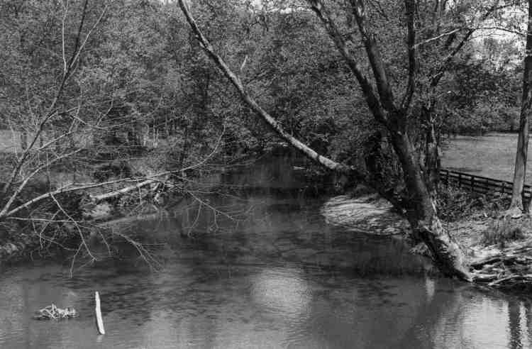
Catoctin Creek, 1974, Photo by John Lewis, from Loudoun Watershed Watch
http://www.loudounwatershedwatch.org/subitem9_3.html
Taylorstown:
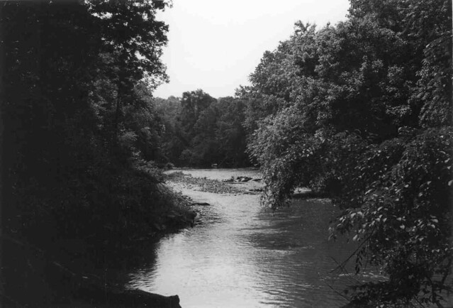
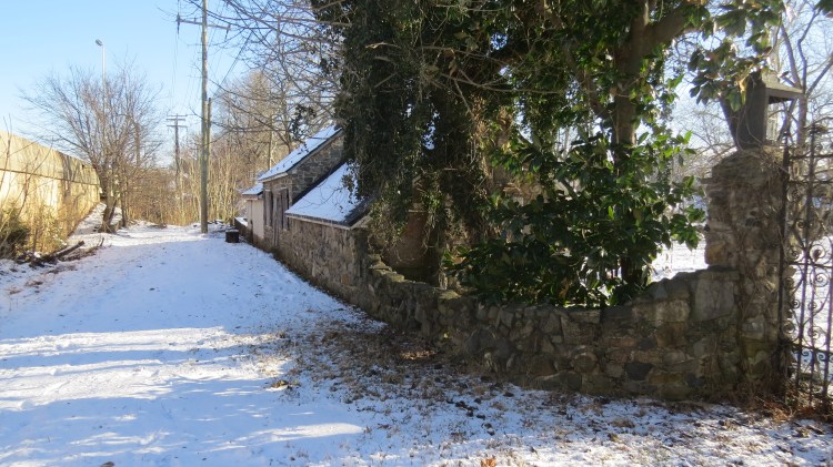
Heading north from route 7 a few miles west of Leesburg, travelers enter the National Historic Landmark of Waterford, Virginia. Most tourists make it no farther than this restored Quaker village. Those willing to continue north for another five miles, roughly following the path of Catoctin Creek, past pastures and dirt roads, reach Taylorstown. Here the historic preservation is less forthright, but no less serious. An old stone mill and general store anchor a few dozen homes.
Its location along Catoctin Creek a few miles South of the Potomac River placed Taylorstown on the top of the Army Corps of Engineers’ list of potential reservoir development sites in 1974. Having failed for three decades to dam the Potomac River, the Corps looked to the creek as a consolation prize—a way to build in a few days of urban water supply into the river. If built, it would have inundated 8,500 acres and submerged the entire town, which, at that point, was 240 years old and had 70 residents.[5]
The battle to save Taylorstown followed many of the classic NIMBY (Not In My BackYard) tropes. These residents were both highly educated and well-connected. Within the group of 140 people that met to organize the Catoctin Valley Defense Alliance, there were lawyers, engineers, retired army and navy brass, a dean of the International School of Law, and a board member of the Interstate Commission of the Potomac River Basin. Residents had the financial resources to hire a top environmental law firm to represent them. A group of white, upper-middle-class professionals organized to defend their adopted landscapes from destruction. Yet the members of the Alliance expanded their arguments beyond these limits. They believed that the damming of Catoctin Creek was not just about the destruction of their property; it was an act of vandalism and a shameful violation. Damming Catoctin Creek would destroy what was, in their estimation, “one of the most historic villages in Loudoun County.”[6]
The alliance worked with local architectural historian John G. Lewis to document and publicize the architecture and genealogical record of each house that would be inundated.[7] Members held a “Don’t Dam Loudoun House Tour” to invite the public to bear witness to what might be lost. These efforts sought to stir their readers to feel the romance of historical renovation. These houses were, in the words of one article, the result of “ample portions of labor, research, and love.”[8] The meticulous process of reconstruction was almost as important as the genealogy and local history in convincing people that these homes were not the product of mass, industrialized construction. Each dwelling had its own conversion narrative. The benefactors found them mired in squalor and despair. They redeemed these homes from decay and, through their efforts, restored them to their former beauty. These were storied places whose history gave them dignity. Their loss would be the loss of that story.[9]
The Alliance buttressed these efforts with the variety of new preservation tools at their disposal. They secured passage of the Catoctin Creek Scenic Rivers Designation Bill in Richmond in March 1977.[10] They worked with county supervisors, Virginia Commission of Outdoor Recreation, and Virginia Historic Landmark Commission to secure historic district status from the state (the county had nine such districts by 1984).[11] Their local efforts, combined with the release of a May 1977 report by the Washington Metropolitan Council of Governments that challenged the need for the additional water storage, forced the Corps to abandon their plans in August 1979.[12] These preservationists protected their rural enclave from a piece of metropolitan infrastructure. Taylorstown endures as home to a mix of commuters and retirees, restored homes and horse farms, all surrounding an old stone flour mill. Historical Preservation made Western Loudoun.
Broad Run Farms
Before reaching any of these Western Loudoun destinations, commuters struggle through what is Eastern Loudoun—strip malls, housing developments, traffic lights (although not as many as there once were), and divided highways. For those willing to risk pulling off on the south shoulder of route 7 as it crosses Broad Run, a small tollhouse is visible twenty feet below along the old bridge. Just north of this local landmark Robert and Barbara Young launched what would become the first housing development in Eastern Loudoun.

The Broad Run Farms subdivision was not the Young’s original plan when they purchased the 706-acre Miskel Farm in 1950. Robert had worked as a lawyer for the U.S. Senate and wanted to try his hand at dairy farming. Within a year they had abandoned the enterprise. It is hard to dabble in dairy farming. Instead the Youngs partnered with a Leesburg real estate man to subdivide their farm. The couple dug a lake along route 7 and began waving down any car that drove by and offering to show them around. Washingtonians had spent the day motoring along the county’s back roads, gazing out at the horses and cattle, soaking in the scenery, and admiring the hard-working country life of Loudoun farmers. Weekend excursions primed them to desire what the Youngs offered—low taxes, good schools, natural beauty, and recreation in the countryside.[13]
By 1953 the Youngs had sold one hundred lots and had eighty houses under construction. The typical mixture of government workers, politicians, and retired military men took up residence in the moderately expensive neighborhood where lots ranged from a half an acre to ten acres.[14] Broad Run Farm’s success inspired imitators. By 1953 the county had approved more than dozen plans for small subdivisions in Eastern Loudoun.[15] By the 1990s, Broad Run Farms would be lost among a series of development projects: Algonkian, Countryside, Cascades, and Dulles Town Center. While it reflected many of the ideals of Western Loudoun, Broad Run Farms became the advance guard of the Eastern Loudoun that would threaten Western Loudoun over the next half a century.
Subdivisions made Eastern Loudoun. . . and therefore defined what Western Loudoun was not but was always in danger of becoming.
Commuters underwrote, consumed, restored, purchased, celebrated, farmed, developed, hunted, defended, and subdivided rural Loudoun County. As I have argued elsewhere, rural people were central actors in this process as well. Yet it was these newcomers who cultivated these fringe landscapes and then defended them. As the postwar period dawned, each group defined these landscapes, whether explicitly or implicitly, in opposition to the supposedly crass, mass-produced imitation lifestyle that was D.C.’s ever-encroaching suburbia. These gentrifiers squared off against development in their efforts to protect Loudoun’s countryside. The project of defending Western Loudoun from sprawl has been inseparable from landscape aesthetics. Preserving these largely private lands for the public good only makes sense to the extent that any resident can access and enjoy their beauty from the public rights of way. The Western Loudoun of health, horses, hamlets, and homesteads is a Loudoun the public sees and enjoys from a car window. It is a commuter’s paradise—a reminder that anyone with a car can drive out past the city and the suburbs and witness the countryside.
What is Western Loudoun?
Western Loudoun is a metropolitan landscape preserved, protected, and promoted as the countryside for anyone willing to look.
 Andrew C. Baker is assistant professor of history at Texas A&M University-Commerce in Northeast Texas. His recent book Bulldozer Revolutions: A Rural History of the Metropolitan South examines the development of the metropolitan fringe outside Washington, D.C., and Houston, Texas.
[1] Scheel, Loudoun Discovered, vol. 4 (Leesburg, VA: The Friends of Thomas Balch Library, 2002) and Jean Herron Smith, From Snickersville to Bluemont: the Biography and History of a Virginia Village, Evelyn Porterfield Johnson and Robert Hoffman, eds. (Bluemont, Va.: Bluemont Citizens’ Association, 2003), especially 144-53; Writers’ Program of the WPA, Virginia: A Guide to the Old Dominion (New York: Oxford University Press, 1940, 1941), 527.
[2] Martha Wolfe, The Great Hound Match of 1905: Alexander Henry Higginson, Harry Worcester Smith, and the Rise of Virginia Hunt Country (Lyons Press, 2015); Higginson’s scrapbooks from the event are housed at the National Sporting Library and Museum (NSLM). Grafton-Middlesex Match, Piedmont Valley, Va., November 1905, Box 7, Alexander Henry Higginson Scrapbooks, 1899-1926.
[3] “Big Hound Match is On,” newspaper clipping, Match Scrapbook.
[4] The Sportsmen’s Review, 1906, 177-178, Folder 21, Box 1, Alexander Mackay-Smith Papers, NSLM.
[5] Piedmont Virginian, June 5, 1974, June 19, 1974, and October 2, 1974 and Washington Star-News Jun 9, 1974, each in Catoctin Valley Defense Alliance (CVDA), Manuscript Collection SC0011, Thomas Balch Library, Leesburg, Virginia
[6] In addition to this, the statement rehashed standard anti-dam arguments. They complained of the loss of county tax base, ecological destruction, and the ruining of open space and farm land. Catoctin Valley Defense Alliance, Official Statement, September 15, 1974, CVDA.
[7] John G. Lewis, “A General History of Taylorstown and the Catoctin Creek Valley from the Potomac to Waterford, Virginia,” August 26, 1974, CVDA.
[8] “Catoctin Valley Threatened by Dam,” Echoes of History, 4 (September 1974), 69-71.
[9] Ray Cheronis, “Foxton Cottage, Taylorstown, VA: A Miracle of Restoration and Reconstruction,” Folder 1, CVDA.
[10] John G. Lewis to Members of the Loudoun County Scenic Rivers Committee and the Goose Creek-Catoctin Creek Task Force, March 4, 1977, Lewis collection.
[11] Calder Loth, ed., The Virginia Landmarks Register, 3rd ed. (Charlottesville: University Press of Virginia, 1987), 238-247.
[12] Washington Post, August 28, 1979.
[13] Scheel, Loudoun Discovered, vol. 1, Goin’ Down the Country, 123-127.
[14] For a example of Broad Run Farms settlers, see Jack Eisen, “New Airport and Suburbia Perk up Loudoun County,” March 21, 1960 and Berta Mikesell, “Formula for a Rich Life,” Folder 2, Box 5, Keep Loudoun Beautiful Collection, TBL.
[15] James Birchfield, “Rural-Urban Broad Run,” Virginia and the Virginia County (January, 1953), 23.

Great article Andrew, keep up the good work! I am always amazed as I drive through western Loudoun and see more and more housing and large data centers going up. We need to save some trees for the next generations.
LikeLike
I grew up in Lovettsville, so really enjoyed going down memory lane as I read your article. My husband, Paul Lenchner retired from tx a&m in 2012. He was a pol.sci. Professor and dept. chair..hi to the history dept.!
LikeLike