
By John Sherrer
Columbia, South Carolina was intentionally designed to be a very livable city from its inception. Founded in 1786 as the Palmetto State’s second capital, its location holds both geographic and symbolic meanings. The city’s original two-mile-by-two-mile footprint was set atop a plain overlooking the Congaree River at the state’s fall line, where the waterway ceased to be navigable from the coast. Conveniently, this natural crossroads rested in the middle of the state, a benefit to lawmakers interested in achieving political parity between Lowcounty elites and growing numbers of backcountry citizens.
As with most fledgling towns or cities, Columbia developed at its own pace and in its own style. Early impressions of this upstart capital, as can be imagined, differed. During his May 1791 visit, George Washington recorded it as “. . . an uncleared wood, with very few houses in it, and those all wooden ones . . ..” A few years later, in 1805, Connecticut native Edward Hooker opined, “There is very little verdure in the town; the soil being too dry and sandy to produce grass. Consequently, the streets are very deficient in that life and freshness of appearance which usually prevails in the towns of New England.”

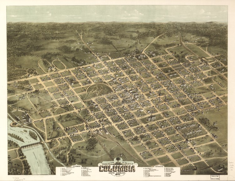
Columbia’s grid-patterned footprint and relationship to waterways featured prominently in Robert Mills’ survey of Richland District. Historic Columbia collection
Further commentators offered their perspectives on the city’s climate . . .
We thought the heat of Philadelphia, New York, and Albany, about this time last year, excessive; but at Columbia its effects in prostrating the strength, and destroying all energy and all capacity for action, was even still greater . . . . I never have suffered so much inconvenience from the heat in Bengal, or any part of India. The soil is extremely sandy, but this contributes much to the healthiness of this place . . .” James Silk Buckingham, 1841
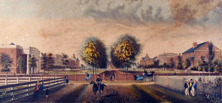
Among the handful of drawings and paintings that artist Eugene Dovilliers depicted of Columbia during the 1840s through 1860s is this likeness of what is today known as the “Horseshoe” at the University of South Carolina. Image courtesy of South Caroliniana Library, University of South Carolina, Columbia.
By the time the well-traveled English author rendered his assessment of the capital city, Columbia had evolved for two generations. Its physical growth included the founding of South Carolina College (1801), the construction of notable public and private buildings and the accumulation of great wealth made possible by the slave-based, agricultural economy that permeated all aspects of life in the city, state and region. By the 1830s, Columbia had matured into what its planners had envisioned: a seat of state government and a center of commerce, transportation and education. By the middle of the 19th century, in 1851, Daniel Webster found Columbia to be “one of the handsomest and nicest looking of our little inland cities.”
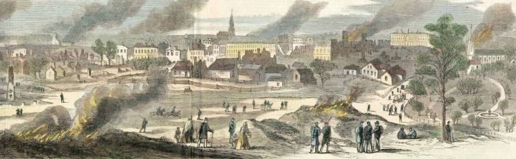
Shortly thereafter, amid this antebellum grandeur, representatives throughout the state gathered at what is today First Baptist Church, not with worship in their hearts but with secession on their minds. While the Union was dissolved slightly later and farther southeast, in Charleston in December 1860, Columbia’s reputation as the birthplace of secession left an indelible impression upon locals and people from away. A little more than four years later, 1/3 of the city lay in fiery ruins, as the Civil War Columbians helped start had returned to its place of origin. (The blame behind the conflagrations remains a hotly debated topic in some circles.)
While physical recovery from the war came in fits and starts, a sea change in the social and racial order that had defined the city for its existence arguably brought greater change more rapidly. As the state capital, Columbia was ground zero for many of the opportunities Reconstruction offered people of color, newly enfranchised and freed, and white citizens who had formerly ceded power to planter elites. Visitor Richard M’Ilwaine penned in 1870, “Columbia was a most agreeable place of residence . . . Its broad avenues, lined with two, three, or four rows of stately oaks, gave it an air of delightful repose. Its fine mansions, sometimes occupying a whole square, surrounded by roses, evergreens and other shrubs and trees, added dignity to the scene, while its less pretentious cottages with their broad verandas were pleasing and attractive . . . .”
This flirtation with a new order proved brief, as Columbia and the remainder of the state slipped back into the antebellum racial status quo with the end of Federal support for Reconstruction’s policies and a re-affirmation of power by former Confederates powerbrokers. “Old South” values underpinned an evolving New South city, an odd coexistence that lasted for the better part of the next century. Paying homage to old traditions, leaders erected monuments to fallen soldiers, aging or dead politicians and to past events for whom meaning was billed as universal, all the while championing the city’s temperate climate, cultural attraction and capable workforce. With these assets in hand, Columbians were poised to build their hometown into a New South city with all the hallmarks of modernity one would expect of such a distinction – large mills, skyscrapers, public transit and fashionable homes.
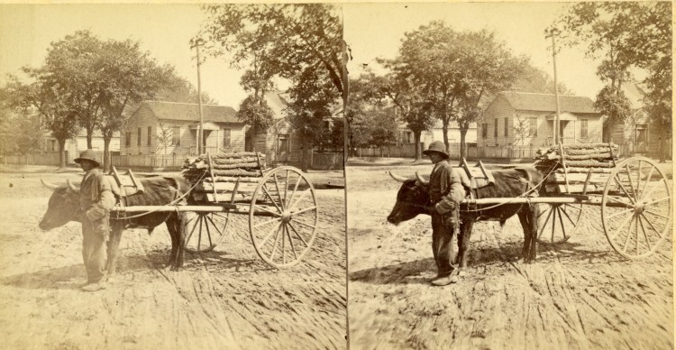
Many advancements made by African Americans during Reconstruction were curtailed during the advent of Jim Crow. Here a child laborer operates an oxcart during the mid-1870s. Historic Columbia collection, HCF 2016.5.1
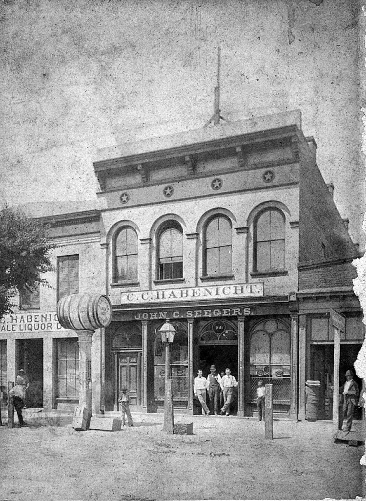
Many commercial enterprises established after Main Street’s destruction during the Civil War would operate for decades thereafter. Today, some of the buildings in which these businesses operated are being put to new uses. Image courtesy of Lynn Boyd

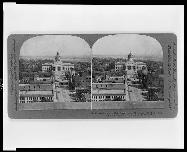
By the late 19th century, Columbia was in the process of turning itself into a New South City by embracing the hallmarks of modernity. Soon after, the city’s early skyscrapers would pierce the skyline. Image courtesy of South Caroliniana Library, University of South Carolina, Columbia
International conflict brought opportunity as Columbians, who once looked askance at Washington leaders, embraced Federal funds that came with the founding in 1917 of Camp Jackson. One of the many World War I cantonment centers established throughout the state, today Fort Jackson ranks as the nation’s largest Army basic training facility. Within the shadows of success lurked deeper issues—educational and health disparities, racial strife and urban decay, all of which were both predicated on and prolonged by Jim Crow laws. In the aftermath of the War to End All Wars, some progressives lobbied for and, to an extent, enjoyed partial improvements to these conditions, but it would not be until the decades following World War II, a period in which Columbia saw extensive growth and redevelopment, that greater change would be realized.
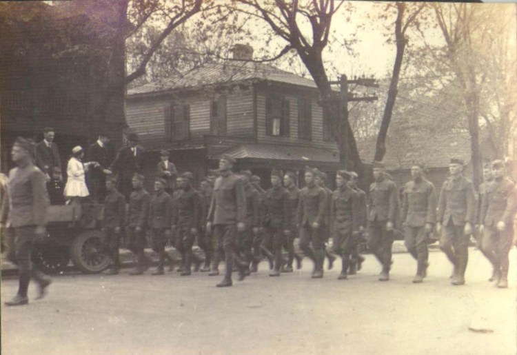
The establishment of Camp Jackson in 1917 forever altered Columbia geographically, socially and financially. Historic Columbia collection
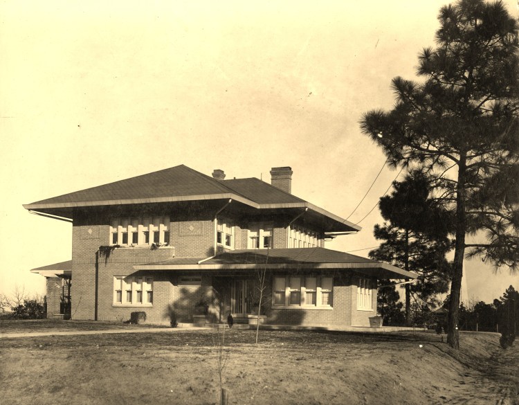
Early suburbanization included many remarkable houses, such as the Prairie Style Powell House in Melrose Heights, and more numerous bungalows, cottages and American Four-Square residences. Image courtesy of the Powell family
Like cities throughout the United States, Columbia in the 1950s through early 1970s was forever altered by Urban Renewal, which reduced generations-old inner-city neighborhoods to either memories or a shell of their former selves. In their place came the University of South Carolina, state, local and federal government and new development that paved the way for a new vision of a city enjoying the prosperity longed for during the lean times of the 1930s and war years. Mid-century architecture reshaped how people interacted—how they worked, recreated and lived—in the city and in its second-generation suburbs, which bloated as upper- and middle-income residents sought larger houses on more land. The stakes were high for those whose commute went from a reasonable walk or a short car ride to a prolonged trip downtown. Widening of main thoroughfares and the building of interstates offered some respite while further stimulating sprawl, a story played out elsewhere throughout the country time and time again. Columbia’s commercial vitality migrated from downtown to the ever-increasing number of suburban malls floating in seas of pavement, a trend that would be repeated every decade into the early 21st century.
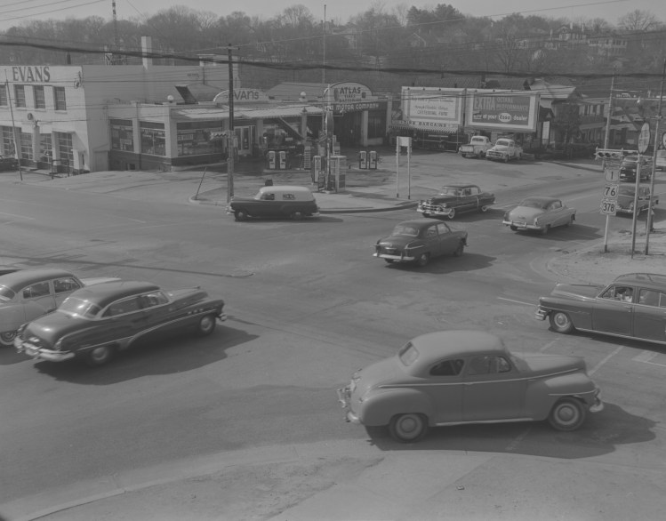
Post-World War II infrastructural improvements, implemented to enhance automobile ingress and egress to Columbia, would drastically change the character of many 19th and early 20th century primary roads, including the destruction of buildings, yards and community cohesion. Image courtesy of South Carolina Department of Transportation
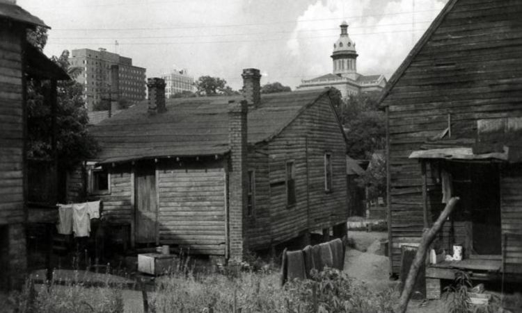
During the late 1950s through 1960s, Columbia leaders set their sights on removing downtown poor and working-class neighborhoods through a “Fight Blight” program whose results heavily impacted African American citizens. Image courtesy of South Caroliniana Library, University of South Carolina, Columbia
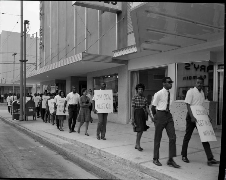
Like in other southern cities, activists demonstrated along Columbia’s Main Street and at lunch counters during the early 1960s. Today, telling those stories is a central part of the ColumbiaSC63 initiative’s work. Image courtesy of South Caroliniana Library, University of South Carolina, Columbia
Concurrent with these larger trends was an appreciation for downtown amenities and a rebirth in interest for older buildings, which had, by the later 1980s, enjoyed a tenuous following. A redefinition of what defined a livable city offered surer footing by the later 1990s and early 2000s, as entrepreneurs, historic preservationists and city planners met success in adapting old buildings to new uses through various incentives. Old department stores, office buildings and textile mills found new life as condominiums or apartments for new urban dwellers—college age through empty nesters—who flock to unique living arrangements. Nearly a generation old, this reinvestment in Columbia has placed the capital city at an interesting crossroad, but one whose paths have been trod, to an extent, by earlier citizens. Revitalization pays great dividends to many while running the risk of displacing long-time owners or tenants. Finding new uses for old places and filling in blank tracts can make for an aesthetically stunning skyline. Meanwhile, such improvement and growth can encourage homogeneity resulting in a monolithic character not in tune with contemporary aspirations for a truly modern city.
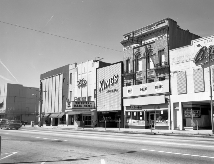
The success of suburban malls during the 1960s through 1980s sapped much of Main Street’s commercial vitality, often leaving behind empty buildings that had been reskinned in mid-20th century slipcover facades in the hope of retaining patrons. Image courtesy of Richland Library
With developers and entrepreneurs adapting 19th and early 20th-century buildings to new uses, Columbia’s Main Street has enjoyed a renaissance during the past decade. Today, Columbia is known as “the real southern hotspot,” which speaks to both its storied climate, as well as its burgeoning attractions.
To learn more about how South Carolina’s capital city got to where it is today, consider exploring the following resources that speak to the history of Columbia, either in a general or detailed sense:
Print Resources
Deas-Moore, Vennie. Columbia, South Carolina. Black America Series. Charleston, SC: Arcadia Publishing, 2000.
Edgar, Walter B. and Deborah K. Woolley. Columbia: Portrait of a City. Norfolk, VA: The Donning Company, Publishers, 1986.
Nell S. Graydon. Tales of Columbia. Columbia, SC: The R. L. Bryan Company, 1964.
Helsley, Alexia. Lost Columbia: Bygone Images from South Carolina’s Capital. Charleston, SC: The History Press, 2008.
Hennig, Helen Kohn ed., Columbia: Capital City of South Carolina, 1786-1936. Columbia, SC: The R.L. Bryan Company, 1936.
Israel, Charles and Elizabeth Durant. Columbia College. The College History Series. Charleston, SC: Arcadia Publishing, 2001.
Jansen, John. Going to Blazes: A 200-Year Illustrated History of the Columbia, South Carolina Fire & Rescue Service, 1804-2004. Evansville, IN: M.T. Publishing Company, Inc., 2005.
Lumpkin, Alva M. Vignettes of Early Columbia and Surroundings. Columbia, SC: The R.L. Bryan Company, 2000.
Maxey, Russell. South Carolina’s Historic Columbia: Yesterday and Today in Photographs. Columbia, SC: The R.L Bryan Company, 1980.
Montgomery, John A. Columbia, SC: History of a City. Woodland Hills, CA: Windsor Publications, Inc., 1979.
Montgomery, Warner M. Eau Claire Memories: A Pictorial History of the Eau Claire Neighborhood in Columbia, South Carolina, 1890-2000. Columbia, SC: The Columbia Star, 2000.
Montgomery, Warner M. Shandon Memories: A Pictorial History of Shandon, a Neighborhood in Columbia, South Carolina. Columbia, SC: The Columbia Star, 2000.
Moore, John Hammond. Columbia and Richland County: A South Carolina Community, 1740-1990. Columbia, SC: University of South Carolina Press, 1993.
Salsi, Lynn Sims. Columbia: History of a Southern Capital. The Making of America Series. Charleston, SC: Arcadia Publishing, 2003.
Scott, J. Edwin. Random Recollections of a Long Life, 1806-1876. Columbia, SC: Charles A. Calvo, 1884.
Selby, Julian A. Memorabilia and Anecdotal Reminisces of Columbia, South Carolina. Columbia, SC: The R. L. Bryan Company, 1905. (REPRINTED 1970)
Sennema, David C. and Martha D. Columbia, South Carolina: A Postcard History. Postcard History Series. Charleston, SC: Arcadia Publishing, 1997.
Sherrer III, John M. Remembering Columbia. Charleston, SC: Arcadia Publishing, 2015.
Williams, J. F. Old and New Columbia. Columbia, SC: Epworth Orphanage Press, 1929.
West, Elizabeth Cassidy and Katharine Thompson Allen. On the Horseshoe: A Guide to the Historic Campus of the University of South Carolina. Columbia, SC: University of South Carolina Press, 2015.
Woody, Howard. South Carolina Postcards, Volume V: Richland County. Postcard History Series. Charleston, SC: Arcadia Publishing, 2000.
Web Resources
Allison Baker, Jennifer Betsworth, Rebecca Bush, Sarah Conlon, Evan Kutzler, Justin McIntyre, Elizabeth Oswald, Jamie Wilson, and JoAnn Zeise, Slavery at South Carolina College, 1801–1865. (Columbia, SC: University of South Carolina Libraries, 2011).
Historic Columbia, Web-Based Tours of Columbia. (Columbia, SC: Historic Columbia Foundation, 2017).
Richland Library, Russell Maxey Photograph Collection. (Columbia, SC: Richland Library, 2013).
Richland Library, South Carolina Postcards Collection. (Columbia, SC: Richland Library, 2017).
South Carolina State Museum. Standard Federal Photo Collection Columbia, SC 1865-1980. (Columbia, SC: South Carolina Digital Library, 2009).
South Caroliniana Library, John Hensel Photograph Collection. (Columbia, SC: University of South Carolina Libraries, 2008).
South Caroliniana Library, Joseph E. Winter Photograph Collection. (Columbia, SC: University of South Carolina Libraries, 2007).
South Caroliniana Library, View of Columbia, S.C. (Columbia, SC: University of South Carolina Libraries, 2007).
Columbia SC 63. Our Story Matters. (Columbia, SC: Historic Columbia Foundation, 2017).
A Columbia native, John has served Historic Columbia in a variety of curatorial and administrative capacities since 1996. In his current position as Director of Cultural Resources, he recently authored Remembering Columbia, which chronicles South Carolina’s capital city from its earliest years through the late 1970s. Previous museum experience includes stints at the Smithsonian Institution’s National Air and Space Museum, the National Trust’s Drayton Hall Plantation, Old York Historical Society in York, Maine and Strawbery Banke Museum in Portsmouth, New Hampshire.
He holds a Bachelor’s of Arts degree in English and history and a Masters of Arts in English from Clemson University, a Masters in Public History from the University of South Carolina and a graduate certificate in museum management from McKissick Museum. Continuing education has involved a summer program with the Museum of Southern Decorative Arts and a certificate from the Southeastern Museum Conference’s Jekyll Island Management Institute.

2 thoughts on “Capital on the Congaree: A Bibliography for Columbia, S.C.”