
This is the first post in Urban and Environmental Dialogues, our January collaboration with the Network in Canadian History and Environment (NiCHE). For other entries in the series, see here.
By Claire Campbell
With sea levels rising, with flooding and storm surge becoming more intense and more frequent, our coastal cities are on the front line—literally—of the effects of climate change. But not only have we warmed those seas and powered those storms by our use of fossil fuels, we have also made our cities more vulnerable to these changes by building into and over tidewater. The asphalt and concrete ringing our harbors in wharves, railyards, and parking lots represent a fundamental, but often overlooked, hazard of the modern metropolis. This built coastal environment is an aspect of urban history that we rarely think about—in part, because we have forgotten the processes by which we built this new shoreline.1
In fact, expanding “made ground” was a common practice in North America’s industrializing cities. To part the waters and make the sea dry land was to create usable, marketable real estate. Artificial or anthropogenic ground was made with deliberate but incremental and varied actions that attempted to corral fresh and salt water simultaneously. This might include draining wetlands, silting estuaries, or burying streams, and, along the harbor, using timber and stone frames of seawalls, cribs, and wharves as bulkheads for all manner of fill, from gravel and ballast to fire and construction debris. The result was the creation of entirely new shorelines. Boston, for example, was remade almost beyond recognition over the course of the nineteenth century.2 In 1864, American naturalist George Perkins Marsh identified “land artificially won from the waters”—whether drainage and reclamation or harbor infill—as evidence for his argument that “man has done much to mould the form of the earth’s surface.”3
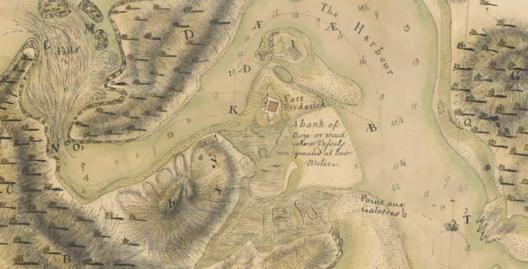
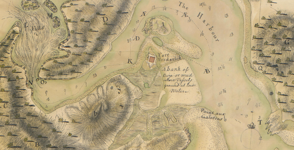
The same was true at Carleton, or Saint John West, in the British colony of New Brunswick. Here expansive tidal flats, washed by one of the most powerful rivers on the eastern seaboard and the highest tides in the world, were initially an invitation (for Wabanaki and Wolastoqiyik peoples) and a caution (for imperial navigators).
What is most astonishing from the view of the twenty-first century is how much of this is gone.
The founding charter of 1785 charged Saint John’s mayor and council with “amending and improving the said river, bay and harbour, for the more convenient, safe and easy navigating.”4 The concept of improvement—the ordering of nature into productive and profitable space—was central to colonial projects of all stripes, and the charter thus gave the city a civic mandate to facilitate commercial shipping. And so it did. By the mid-nineteenth century, Saint John was one of the most important ports in British America.
… the most important and wealthy town in New-Brunswick, and may well be called the New York of the Province. The trade of this City, considering its age, is immense, and rapidly increasing, and from the excellence of its harbour, accessible at all seasons of the year, and the enterprise of its merchants, it will soon attain and hold a high rank among the first trading cities of America.
~ Peter Fisher, 18385

While the commercial center of Saint John (or Parrtown) was crowded with slips nearest the market square, across the harbor the wide flats of Carleton were enclosed differently, for uses that required more space: walled off as a mill pond, then pierced by a few wharves first for local ferries and then the larger “accommodation of Sea-going Steamers.”6
This, then, being the discovery of this half century, turn your eye, as we proceed, where the flats of Carleton Point inside the breakwater used to be visible. Where now are the reaches of mud and the forests of fishing brush that once covered so many acres there? Gone; and in their place a remarkable array of dry docks and shipyards, containing scores of invalid craft, here for their health.
~ Saint John, Past and Future (1882)7
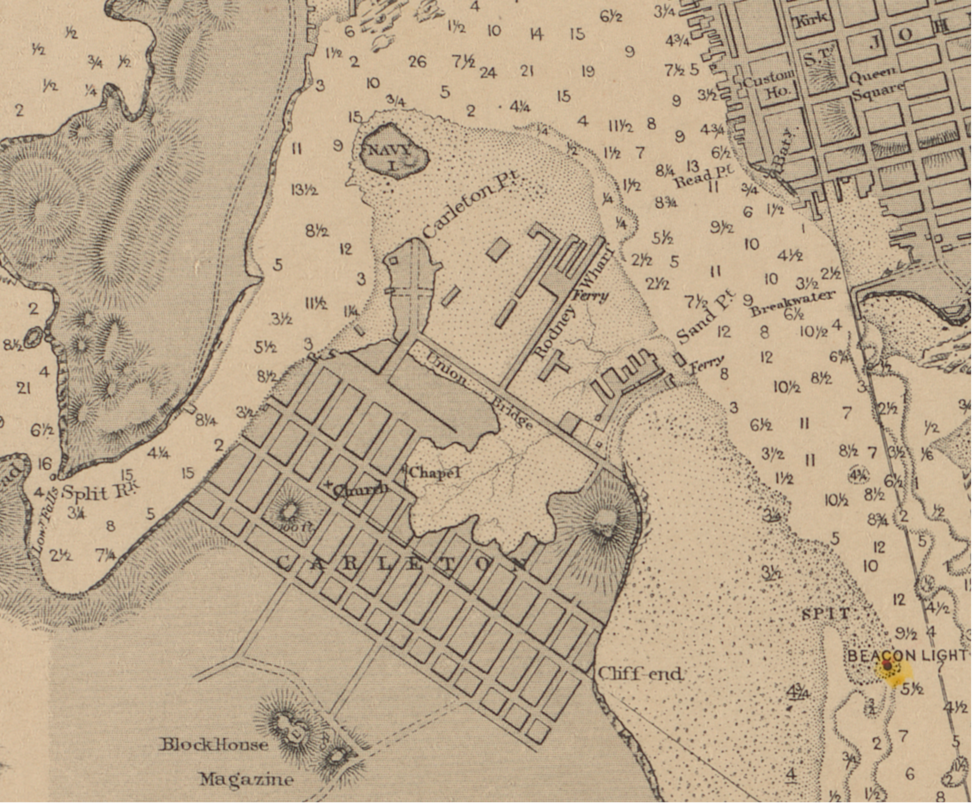
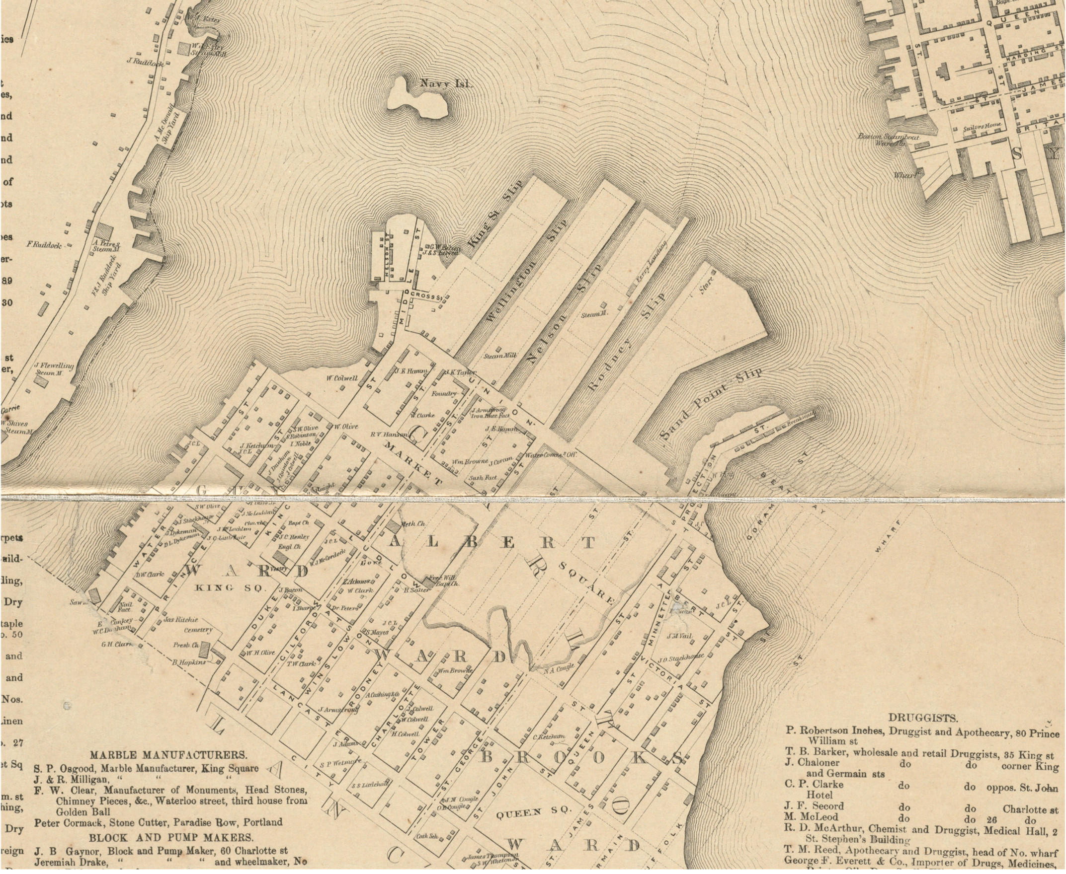
But it was the railway, and specifically the Canadian Pacific Railway, with its networked complex of loading docks and rail spurs, that permanently remade the original expanse of “ouze or mud” into asphalt.


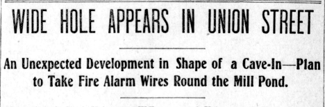
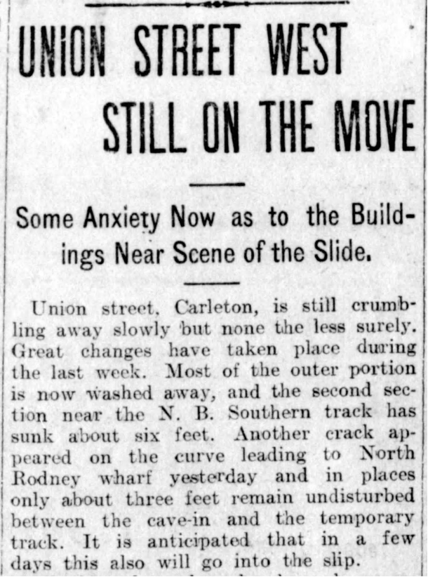
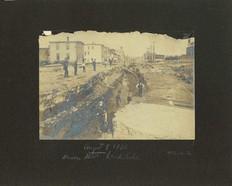
By the turn of the twentieth century, Carleton was a dense neighborhood built in the contours of the tidal flats, which still refused to entirely cooperate with urban plans.
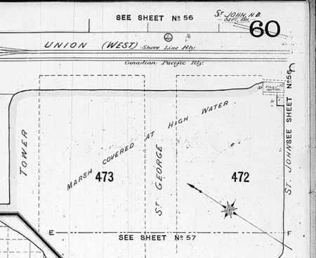
Especially when the streets started caving in.
Still Saint John, like other cities, was not to be dissuaded. The same process of infill and waterfront re/construction would be repeated on the city’s eastern edge at Courtenay Bay, on an even greater scale – including the largest oil refinery in Canada.
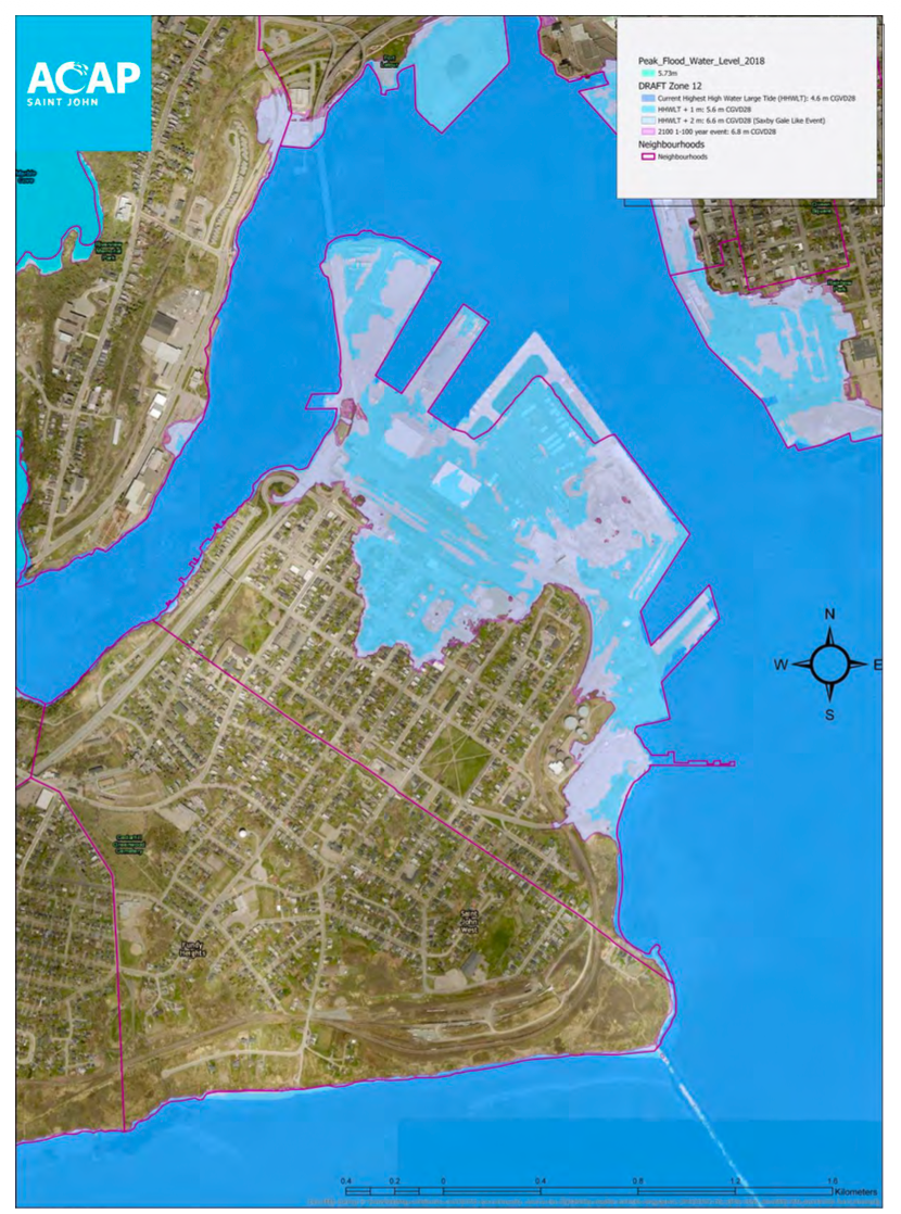
But the twenty-first century promises something different—or, more precisely, something familiar, but forgotten. Sea levels are predicted to rise in such a way as to fill almost exactly the footprint of the eighteenth-century flats marked on older maps. Climate change is going to make it impossible for us to ignore how much of the shoreline we know and occupy is constructed, artificial ground, built for the demands of a particular historical moment, the industrial age.
Carleton is a cautionary tale in the new climate era. Rising seas are finding again their older shores.8
Claire Campbell is a professor of History and affiliate faculty in Environmental Studies & Sciences at Bucknell University. Her most recent scholarship is appearing as Cities by the Sea: Urban Coastlines in Atlantic Canada in the Nature | History | Society Series with UBC Press (2026).
- Jared Orsi, Hazardous Metropolis: Flooding and Urban Ecology in Los Angeles (Berkeley: University of California Press, 2004). Martyn Bowden, “Industrial Portland,” Plate 45, in Historical Atlas of Maine, eds. Stephen J. Hornsby and Richard W. Judd (University of Maine Press, 2015; Carola Hein and Dick Schubert, “Resilience, Disaster, and Rebuilding in Modern Port Cities,” Journal of Urban History 47:2 (2021), 235–249.
↩︎ - Nancy Seasholes, Gaining Ground: A History of Landmaking in Boston (MIT Press, 2003), which includes an excellent discussion of the structural processes of infill. ↩︎
- George Perkins Marsh, Man and Nature: Or, Physical Geography as Modified by Human Action (1864), 13, 330–332. ↩︎
- The Charter of the City of Saint John (1785), in Thomas Wetmore files, S89-6, Saint John recorder’s bound compilation, New Brunswick Museum; reprinted in Canada’s First City – Saint John, N.B.: The Charter of 1785 and Common Council Proceedings (Lingely Printing, 1962). ↩︎
- Peter Fisher, Notitia of New-Brunswick, for 1836, and Extending Into 1837 (London: H. Chubb, 1838), 66. While the reference to New York was meant in terms of port trade, the charter of Saint John – a city founded by evacuated Loyalists – was modelled on an older charter to New York City. ↩︎
- “An Act to provide for the erecting and making certain Wharves and improvements in the Harbour of Saint John” (1852). See the British North American Legislative Database, hosted by UNB. ↩︎
- Saint John, Past and Future (Ellis, Robertson, 1882), 21. ↩︎
- Appendix A: “Coastal Hazard Flood Risk Mapping,” Atlantic Canada Action Program, Climate Change Adaptation Plan for Saint John (2020), 62-68. https://static1.squarespace.com/static/52efdd04e4b0e9a106d08683/t/5faa90da94221021f4cb3939/1605013759233/ETF+Climate+Change+Adaptation+Plan+%5BFinal%5D+Compressed.pdf ↩︎
